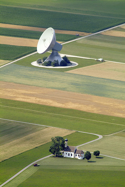
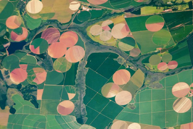
Sticky Postings
All 242 fabric | rblg updated tags | #fabric|ch #wandering #reading
By fabric | ch
-----
As we continue to lack a decent search engine on this blog and as we don't use a "tag cloud" ... This post could help navigate through the updated content on | rblg (as of 09.2023), via all its tags!
FIND BELOW ALL THE TAGS THAT CAN BE USED TO NAVIGATE IN THE CONTENTS OF | RBLG BLOG:
(to be seen just below if you're navigating on the blog's html pages or here for rss readers)
--
Note that we had to hit the "pause" button on our reblogging activities a while ago (mainly because we ran out of time, but also because we received complaints from a major image stock company about some images that were displayed on | rblg, an activity that we felt was still "fair use" - we've never made any money or advertised on this site).
Nevertheless, we continue to publish from time to time information on the activities of fabric | ch, or content directly related to its work (documentation).
Monday, March 21. 2011
Agricultural Landscapes Seen From Space
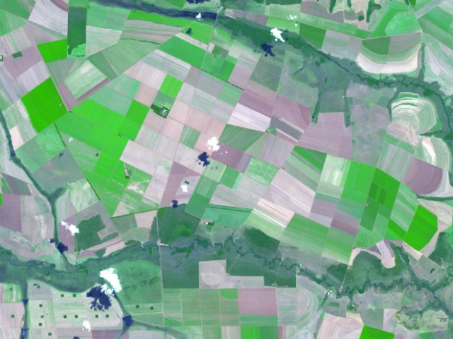
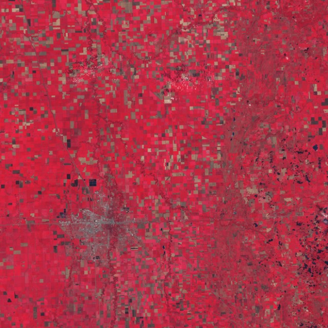
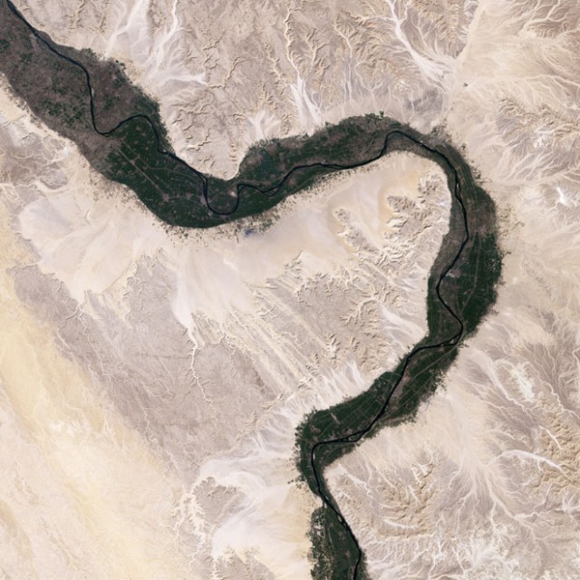
On daily basis we come across images that are built using various code techniques, whether this be pixelation, glitch, particle fields, swarms, reaction diffusion, looking that these images on Wired Science, it’s amazing to see the similarities between the works we create and the environment we inhabit. Even more apparent when we consider that they bare no correlation to one another and the large gap in scale that exists between them. Likewise, the images below appear strangely “Digital”…
Agriculture is one of the oldest and most pervasive human impacts on the planet. Estimates of the land surface affected worldwide range up to 50 percent. But while driving through the seemingly endless monotony of wheat fields in Kansas may give you some insight into the magnitude of the change to the landscape, it doesn’t compare to the view from above.
more on Wired Science





Personal comment:
Pixelated landscape!
Tuesday, May 25. 2010
Sixty-Six Percent Natural
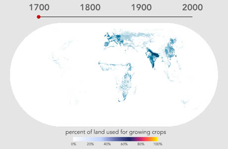
IMAGE: Screen grab showing global agricultural land-use in 1700, from World Cropland, Bill Rankin, 2009.
At Bill Rankin’s fantastic Radical Cartography site you can see an animation that shows the intensification and spread of agricultural land-use around the world over the past three hundred years.
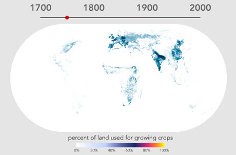
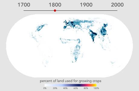
IMAGES: Screen grabs showing global agricultural land-use in 1750 and 1800, from World Cropland, Bill Rankin, 2009.
I could spend hours with these maps: for example, it’s amazing to see that agricultural activity in India in 1700 is as intensive, if not more so, than in the traditional bread-baskets of the Caucasus or the densely populated areas of Northern Europe. The persistent un-farmed patch of France’s Massif Central is also interesting: even the Alps appear to have more agricultural activity.


IMAGES: Screen grabs showing global agricultural land-use in 1850 and 1900, from World Cropland, Bill Rankin, 2009.
Rankin notes that the major trend of the past three hundred years is simply the intensification of farming practices on land that was already agricultural, “punctuated by several episodes of rapid expansion into previously untapped areas: the Great Plains in the late nineteenth century, Argentina in the early twentieth century, and in last few decades, Brazil and central India.” He also points out rare but occasional declines in agricultural density: in the “central Amazon, northern Patagonia, or the Appalachian Piedmont after World War II.”


IMAGES: Screen grabs showing global agricultural land-use in 1950 and 1992, from World Cropland, Bill Rankin, 2009.
You might be wondering how Rankin knows what percentage of land was used for growing crops in 1700, before much of the world had even been charted, let alone systematically analysed in terms of land-use.
The dataset on which Rankin’s animation is based was developed by Navin Ramankutty and Jonathan Foley, whose methodology relied on an assessment of global agricultural land in 1992, at “5 min spatial resolution” (about 10 km at the equator), by “calibrating a remotely sensed land cover classification data set against cropland inventory data.” They then compiled an “extensive database of historical cropland inventory data, at the national and subnational level, from a variety of sources,” and processed that information through their 1992 land cover/inventory algorithm, in order to arrive at a historical reconstruction.
As Ramankutty and Foley freely acknowledge, the resulting map is a guess, albeit an extremely educated one that also matches what we know of “the history of human settlement and patterns of economic development.”
As always, much of the interest in maps like these lies in thinking about what is or isn’t measured—and why. Personally, I’m intrigued by the intensification metric, and the visual implication, as Bill Rankin puts it, that “many agricultural areas are at close to 100% exploitation.” This doesn’t seem quite right: Ramankutty and Foley are measuring agricultural land use (and only at a resolution of about 10 km at the equator), not productive potential. After all, surely an area of land could be solely devoted to agriculture and yet produce wildly differing yields depending on the crops sown and the farming techniques used?
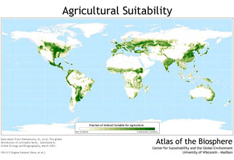
IMAGE: Map showing the suitability of land for agriculture. The map (larger view here) is derived from more data sets developed by Ramankutty and Foley, available at the Atlas of the Biosphere.
Elsewhere, Ramankutty and Foley have also collaborated to map agricultural potential, based on “the temperature and soil conditions of each grid cell.” Somewhat implausibly, since agriculture both shapes and is shaped by human civilisation, the suitability rating ignores human inputs—urban sprawl, artificial irrigation, topsoil creation—altogether.
Stepping even further away from plausibility (and human intervention), Ramankutty and Foley subsequently produced a fascinating map of potential vegetation, showing “the vegetation that would exist at a given location had human forms of land use never existed.”

IMAGE: Map of potential vegetation. The map (larger view here) is derived from more data sets developed by Ramankutty and Foley, available at the Atlas of the Biosphere.
It is an alternate surface of the earth, carefully surveyed and classified by a human civilization that could not have existed in order for it to be a reality.
On a similar note, Colorado State University researcher David Theobald has designed a new system for evaluating and mapping the “naturalness” of a landscape. In his review, Rob Goldstein describes Theobald’s methodology thus:
Specifically, Theobald used existing land use data to apply scores at a scale of 30 metres. Urban/built-up areas, roads and cropland were assigned a score of “0.” Natural areas (i.e. forests, grassland, wetlands, etc.) were assigned a score of “1.” Roads and rural development negatively impacted the scores of adjacent areas.
Using this technique, Theobald arrived at “a natural landscape score of .6621 for the conterminous United States in 2001.” In other words, the lower forty-eight states are sixty-six percent “natural,” and only one-third human-designed, or “unnatural.”
The project seems flawed on several levels (it is somewhat incredible that Owens Valley, with its hijacked river and poisonous lake-bed, could receive the “highest naturalness” scores under any rubric), but the paradox of its premise is fascinating—that a pure form of nature can be carefully located and recognised as such by humans whose activity otherwise renders impossible its very existence.
Theobald suggests that his system is a useful tool for conservationists seeking to prioritise their efforts. To me, however, it is more interesting as a geographic expression of impossible nostalgia—the land-use database equivalent of medieval monks calculating how many angels could dance on a pin.
Personal comment:
This is to be put in parallel with Jared Diamond's book: Guns Germs and Steel: The Fates of Human Societies that explain the evolution of human socities from a geographic/food point of view, that would in a way generate, according to Diamond, social and cultural diversities. An eye opening book on the interaction between environment and human societies.
Just one comment as well about the title: I don't think any percent of land and atmosphere is natural anymore. We've totally changed the quality of air (not saying climate) through human activities at least since the industrial period (but in fact much earlier, agricultural, etc.) and we could also consider the change of perception in landscape through communication electromagnetic waves. A large part of the landscape has now become a sort of "invisible urban territory" though electromagnetic networking.
Monday, February 15. 2010
Urban Farming in numbers
Interesting study by MVRDV, The Why Factory and Stroom Den Haag.
A lot has been said (through) on Urban Farming, but many don’t consider their feasibility.
I´m not being pessimist (I grow some of my own vegetables and herbs), but I think that urban farming goes more in the direction of the last phrase of the video: “could it (urban farming) help bringing some agriculture into the cities to bring us closer to our food again?”.
Animation by Wieland Gouwens
Update: The same study applied to Manhattan
-----
Via ArchDaily
Personal comment:
We do hear a lot about "urban farming" these days. Here an interesting study by the dutch connection (a.k.a "data style") about it, which shows that it won't be an easy thing to manage to become significant for the "sustainable"approach...
Friday, January 22. 2010
Rebooting Britain: Transform cities into lush jungles
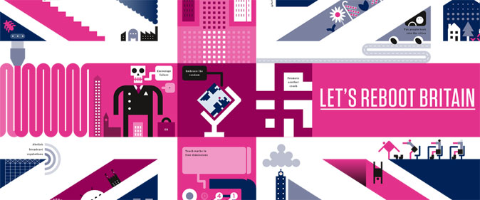
Photo: Peter Grundy
This article was taken from the January issue of Wired UK magazine. Be the first to read Wired's articles in print before they're posted online, and get your hands on loads of additional content by subscribing online
Cities may be more energy-efficient than the countryside, but we can radically enhance that efficiency with existing and achievable technology plus a little imagination, making cities carbon neutral and all but self-sufficient.
Here's a four-step plan:
1 Build intelligently Construction of new buildings consumes materials and creates massive carbon debt. Wherever possible, existing stock should be refurbished and retrofitted using bioarchitectural techniques and recycled and sustainable materials to enhance energy conservation, reduce water consumption, and maximise use of rainwater. Turn office buildings into the equivalent of high-tech beehives; shopping malls into jungle bazaars; point blocks into pinnacles dripping with vines and pocket forests.
2 Go Nuclear Present experience shows sustainable sources of energy - from buildings equipped with solar panels and wind generators to plants generating biofuel and electricity by digesting garbage - will not satisfy the energy demands of large cities. A new generation of compact long-life nuclear power plants such as India's thorium reactor or South Africa's pebble-bed design will plug the power gap and produce small quantities of waste that, unlike carbon dioxide generated by oil- and coal-fired plants, can be safely stored in vitrified form.
3 Stop using fossil fuels Cities are at present vulnerable to the smallest interruptions in oil and gas supply. The first step in cutting this dependency should be a ban on private car ownership in metropolitan areas. Even a sprawling city like London can be comfortably navigated by walking, cycling, and use of public transport - powered, like delivery vehicles servicing businesses and homes, by batteries, biofuels, or hydrogen fuel cells. The great tidal flows of commuters could be reduced by rezoning commercial areas for residential use and introducing workshops and offices into residential areas, as in the human-scale, mixed-use street plans of medieval cities.
At present, 30 per cent of London's carbon budget is consumed by commercial aircraft flights. In the future, all flights should use only biofuels produced by farming GM microalgae that mop up nutrients from sewage and produce ethanol and lipids. Even without genetic modification some strains of algae already yield more than ten to 20 times more biodiesel than rapeseed; the most efficient grow in saltwater, so would not compete for potable water; and fuel production powered by photosynthesis would be carbon neutral.
4 Embrace GM Parking structures and unwanted office and residential tower blocks could be converted to vertical farms where high-value GM crops, produced by open-source research rather than agribusiness, modified for perennial growth and maximum productivity, could be grown year-round using advanced hydroponics systems (drug dealers have already embraced this technology to produce crops of GM marijuana in ordinary houses). Walls and streets would be turfed with tough GM grasses and sedges; these, and thick plantings of trees lining roads, would absorb carbon dioxide and provide equitable microclimates.
From the air, the ideal green city should resemble Mayan ruins poking out of a lush forest. Under the canopy, there'll be densely populated but diverse and vibrant streets humming with every kind of human life. Utopian? You bet. But unless we get a lot smarter very quickly, we'll get the future we deserve: sweltering resource-poor mega-favelas salted with the high-security enclaves of the hyper-rich. Time to choose.
Paul McAuley is a biologist and multi-award-winning science-fiction author. His new novel Gardens of the Sun is published by Gollancz.
Read other articles from the Rebooting Britain series
- Tax people back into the cities
- Teach kids to see in four dimensions
- Exercise a green foreign policy
- Open democracy to the online masses
- Reinvent the way we live together
- Live life as a lottery
- Pull the plug on broadcast regulation
- Enact beta versions of new laws
- Make carbon emissions hurt
- Slash the universities and go virtual
- Make policy using prediction markets
- Promote another crash
- Ditch Twitter: it's dangerous for democracy
- Encourage failure
- Make education more flexible
- Set government data (radically) free
Want more Wired UK magazine? Get your copy every month by subscribing online today
-----
Via Wired UK
Edible Schoolyard / Work AC
Work AC, in collaboration with Edible Schoolyard NY and the Alice Waters’ Chez Panisse Foundation, is designing a new schoolyard for PS216 that will offer the young New Yorkers a different learning experience. The Edible Schoolyard is designed as a series of interlinked sustainable systems where the building will produce energy and heat, collect rainwater, process compost and sort waste with an off-grid infrastructure.
More images and more about the school after the break.
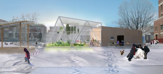
The school includes a kitchen classroom and mobile greenhouse where children are brought together in a learning environment that also promotes eco-friendliness. The roof of the kitchen classroom, a room that provides the facilities for up to 30 students to prepare meals together, channels rain water for reclamation. The mobile greenhouse extends the growing season by covering 1600sf of soil in the colder months and gardens will allow the children to care for plants.
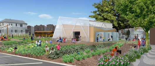
A systems wall, a series of spaces that include a cistern, space for composting and waste-sorting, solar batteries, dishwashing facilities, a tool shed and a chicken coop, rests on the opposite side of the yard.
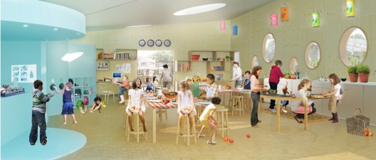
The project is a great way to introduce sustainable methods into children’s lives at an early age. The “edible” element will definitely pique children’s interests and help the next generation realize the importance of the eco-friendly movement.
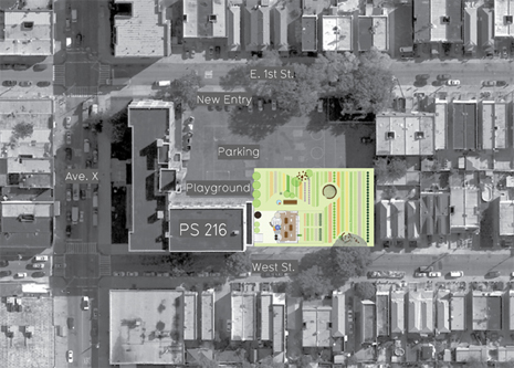
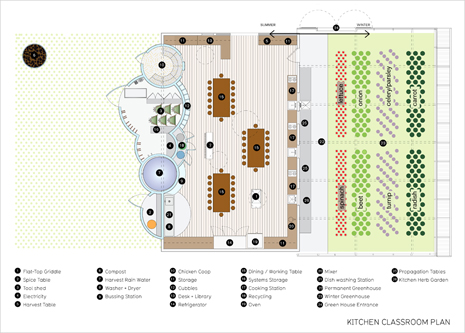


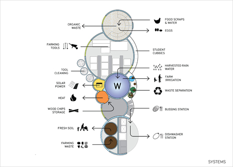
All images courtesy of WORKac
-----
Via ArchDaily
Related Links:
Saturday, September 26. 2009
«Notre modèle de consommation alimentaire n'est pas soutenable»
Recueilli par PHILIPPE BROCHEN

Dans un magasin de Lucknow, dans le nord de l'Inde, le 6 juillet. (REUTERS)
Aurélie Trouvé, docteur en économie et ingénieur agronome, est enseignante-chercheuse à l'Agrosup Dijon et copréside la branche française d'Attac. Elle réagit aux déclarations de la FAO (Organisation des Nations unies pour l’alimentation et l’agriculture) selon laquelle il y aura 2,3 milliards de bouches de plus à nourrir en 2050 - soit 9 milliards d'être humains - et qu'en conséquence une hausse de 70% de la production agricole est nécessaire.
Les chiffres fournis par la FAO vous étonnent-ils?
Pour l'augmentation de la production agricole de 70%, non, il n'y a rien d'étonnant s'il n'y a pas de prise de conscience et de transformation de notre mode de consommation alimentaire, notamment dans les pays du Nord.
Pour des néophytes de la question il est difficile de comprendre qu'une augmentation de la population mondiale d'environ un tiers nécessite d'augmenter la production agricole de 70% pour pouvoir nourrir tout le monde.
Dans les pays du Sud, notamment en Asie et en Afrique, il y aura une augmentation des besoins pour des raisons démographiques et aussi parce qu'on assiste actuellement à une transformation du modèle alimentaire. Il tend notamment à imiter les pays du nord, notamment en ce qui concerne l'alimentation carnée. Et il ne faut pas oublier que pour produire une kilocalorie animale, il faut plusieurs plusieurs kilocalories végétales. C'est une des explications de la disproportion entre l'augmentation des besoins alimentaires de 70% et la hausse de la population qui n'est que d'un tiers.
Une telle augmentation de la production agricole en si peu d'années vous semble-t-elle possible?
C'est une question qui fait couler beaucoup de salive et d'encre parmi les agronomes et les scientifiques. Cela doit surtout amener à une prise de conscience, parce qu'aujourd'hui le modèle de consommation alimentaire des pays du nord est non soutenable à une échelle mondiale. Si toute la population planétaire se nourissait comme un habitant des Etats-Unis, on ne pourrait nourrir que 2 milliards d'être humains au lieu des 6 qui peuplent actuellement la Terre.
Parmi les enjeux, il y a donc une question culturelle liée à la mondialisation, mais aussi des raisons politiques. Non?
Evidemment, et ces raisons politiques ont induit des choix. Aujourd'hui, la plupart de la viande vient d'Amérique à des prix qui sont artificiellement très bas. Parce que cette viande provient de très grandes exploitations qui produisent massivement et qui, pour beaucoup, ont des coûts sociaux et environnementaux très faibles. Notre alimentation très carnée s'appuie aussi sur une production qui induit un accaparement de plus en plus important des terres dans ces pays et concurrence directement l'agriculture vivrière. Au Brésil, il y a ainsi des millions de paysans sans terre.
L'UE est-t-elle aussi responsable de cette situation?
En Europe, on a mis des droits de douane proches de zéro sur la question de l'alimentation animale. L'UE a donc avantagé l'importation alors que l'on aurait pu avoir une production locale liée à l'herbe. Plus globalement, l'UE a développé une logique exportatrice, à l'opposé d'une logique d'autonomie alimentaire et de relocalisation des activités. Résultat: nous ne sommes pas autosuffisants sur le plan alimentaire, puisque nous importons plus que nous n'exportons, malgré des conditions agronomiques très favorables.
Que préconisez-vous?
Il faut réinterroger profondément la libéralisation des marchés qui est le dogme actuel des négociations internationales. Cette libéralisation des marchés est orchestrée par le FMI, la Banque mondiale et l'OMC depuis les années 80. Elle est toujours en marche et est soutenue par les pays les plus puissants.
La crise alimentaire mondiale nous a montré que cette libéralisation des marchés était destructrice pour l'agriculture vivrière, notamment des pays du sud, et qu'elle induit une très forte volatilité des prix qui fragilise les petites exploitations et sélectionne les plus compétitives. Ces petites exploitations paysannes, ultra majoritaires, sont directement concurrencées par l'agriculture industrielle des pays du Nord et l'agriculture ultra compétitive des grandes exploitations du Sud qui commettent des dégâts humains et environnementaux considérables.
Pensez-vous qu'on puisse encore changer de modèle économique et politique agricole?
Je pense surtout que c'est nécessaire et que nous n'avons pas d'autre choix. Un exemple instructif: pour l'année 2009, nous sommes en train d'exploser les chiffres de la faim dans le monde. Aujourd'hui, c'est davantage une question d'inégalités mondiales que de quantité, davantage un problème de juste répartition et de règles alimentaires.
Faut-il, comme pour le climat, agir dès à présent?
L'agriculture a une place dans la crise climatique: elle est à la fois victime (les régions qui souffrent déjà de la faim seront les plus touchées par le réchauffement, les régions tropicales et subtropicales vont voir leur potentiel agricole touché) et responsable (essentiellement le modèle agricole intensif et industriel des pays du nord). N'oublions pas par ailleurs que l'agriculture intensive est dépendante des ressources fossiles, qui sont en cours d'épuisement.
En Asie et ailleurs, on a vu des stagnations des rendements agricoles, stagnations imputées au modèle intensif: à savoir, l'épuisement des sols et des ressources hydriques, la résistance aux maladies et aux ravageurs (animaux nuisibles aux cultures)... De même, sur les cultures OGM en Argentine, on a vu des retournements de rendements...
Y a-t-il quand même de quoi garder un peu d'espoir ou tout est d'ores et déjà foutu, surtout pour les pays du Sud?
Ce qui est certain, c'est qu'il va y avoir une tension de plus en plus forte sur les terres. Si on ne change pas de mode de développement et de consommation, on va avoir besoin de terres à l'extérieur pour les besoins alimentaires et aussi pour la production d'agrocarburants par des grandes entreprises privées et les pays.
Mais si je suis une chercheuse engagée, c'est que j'ai de l'espoir, tout en sachant qu'il n'y a pas d'autre choix que de changer de modèle de développement et aussi les politiques qui les régulent. Il ne faut oublier qu'actuellement, trois quarts des personnes qui sont sous-nutries dans le monde sont des paysans.
Alors, quel modèle adopter?
Des centaines d'experts en agronomie de l'IAASTD, un organisme qui, pour faire vite, peut-être comparé au Giec pour le climat, mettent en avant l'agro-écologie, les connaissances indigènes, le lien de la production et des connaissances agricoles avec le fonctionnement des écosystèmes.
-----
Via Libération
Wednesday, July 22. 2009
Filling Urban Voids . . . With Farms?
by Lisa Stiffler
Ripples, and sometimes waves, of the economic tsunami continue to roil through cities across the United States. One product of the downturn is stalled real estate projects. Many shelved projects have left vacant lots, derelict buildings, or parking lots where housing or office space was planned. The need to put these spaces back into use has motivated some great thinking about how to integrate open space and farming into the urban landscape. Interestingly, this is not a new problem. Philadelphia has been working on projects to convert “brown space” to “green space” for years. Philadelphia’s voids were created by migration from the cities to outlying urban areas, not a specific downturn. In 2005 they held an international design competition called Urban Voids. The point is, Philly has paved the way—er, broken new ground—for other cities to follow. And the best ideas about what to do with vacant property have to do with food.
You can review some of the design contest entries here. For the most part these ideas are at the edge of feasibility, but that’s the point of design competitions: to push the limits of what conventional wisdom says is possible.
Here is an aerial view.
Some more detailed images. Here is a pasture for urban cows.
We wouldn’t want to leave out the chickens.
What is a farm with out some goats?
Farmadelphia knits together a couple of ideas we’ve discussed about urban farming and food insecurity. Specifically Farmadelphia challenges us to consider the end of the dichotomy between rural and urban. This idea of connecting farming with urban life is not new to the Northwest. And new doors are opening as urban properties remain undeveloped.
Seattle’s Greg Smith has allowed a great food truck to park right around the corner from the Sightline offices on property that is no longer going to be developed. Portland has been doing this for years. Seattle, Portland and Vancouver allow chickens and thanks to City Councilmember Richard Conlin Seattle allows goats.
Seattle has a municipal farm, the Marra Farm, that is not only in an urban area but in part of the city that’s downright industrial, South Park. The Marra Farm is a working farm that is right near the day-lighted Hamm Creek. The Marra Farm was one of the many farms operated by Italian immigrants in the Duwamish River Valley that supplied produce to the Pike Place Market in the early years of the last century. Today it provides for a city food security program called Solid Ground. Portland and Vancouver have similar programs. Vancouver has also entertained a skyscraper farm called Inhabitat.
Putting farms on more and more vacant lots makes sense on several levels: transportation costs would be cut for hauling produce, green spaces help reduce runoff into streams, rivers, lakes, and oceans; healthy food would be more available in more neighborhoods. And just as important urban farming reminds us food doesn’t come from the grocery store but from the land, animals and water.
So perhaps, one day, our region might realize a version of Frank Lloyd Wright’s Broadacre City, a city of tall buildings surrounded by open space and farms. Something about this concept is very appealing.
It’s the ultimate: density paired with open space and proximity to healthy food. But…maybe it’s the flying machines that would really seal the deal.
This article originally appeared on sightline.org
-----
Via WorldChanging
Personal comment:
Dans la continuité de la réflexion sur l'"urban farming", avec ici un lien historique intéressant vers Frank Lloyd Wright (Broadacre City).
Tuesday, July 21. 2009
City of London plans guerrilla allotments for vacant building sites
Article from the Guardian by John Vidal (16th June 09) about temporary "grow gags" being moved guerrilla style across London to provide food for city dwellers.
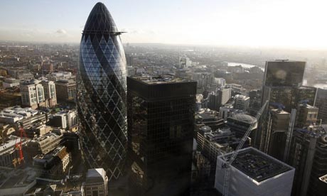
"The local authority wants some of its 9,000 residents to use sites awaiting development to grow food in giant grow bags
The City of London has only 22 acres of open space, mostly in old burial grounds and small squares, but the recession has left many building sites vacant. Photograph: Martin Argles
The Square Mile, capital of commerce and the site of Britain's most expensive real estate, could soon host some of its first temporary allotments with giant "grow bags" set up on building sites.
The City of London, one of the few authorities not to have formal allotments, wants some of its 9,000 residents to use the spaces to grow fruit and vegetables. The authority has only 22 acres of open space, mostly in old burial grounds and small squares, but the recession has left many building sites vacant.
"There are plenty of temporary sites awaiting development and there is no reason why, if carefully done, they could not be turned to other uses," said Sue Ireland, head of open spaces in the City.
"We are trying to identify a site on the edge of the Square Mile that would be vacant for between 18 months and two years. Grow bags are one possibility. They could be butted up together and moved as and when the developers need to start work."
The grow bags idea came from a music festival where she saw huge sandbags being moved around by fork-lift trucks. "I was thinking how flexible they could be. Grow bags would allow people to grow carrots and peas. You would have to secure the site and give developers the confidence that the bags could be moved. But if the right site came up, I am sure money would be available."
The idea of using temporary sites to grow food is not new. In New York, community gardeners have moved from one site to another for more than 30 years.
The Commission on Architecture and the Built Environment (Cabe) calculates that Britain has nearly 74,100 acres of vacant or derelict brownfield land and other unused public space that could enhance cities or help communities.
"Other cities have guerrilla gardens, why not guerrilla allotments?" says Sarah Gaventa, director of the Cabe Space, the government's official adviser on public space, who is a resident of the City of London. "There is lots of dead space in the Square Mile. It's ridiculous not to use it for local food production.
Chris Baines, an ecologist and author, added: "Land 'in limbo' is an incredibly valuable resource. Its temporariness is its strength. It allows you to be more innovative because you know it is not going to be permanent."
The City of London initiative follows dozens of other grassroots projects to grow food in cities where allotment space is at a premium and there is growing demand for local food. Yesterday it was revealed that the Queen had turned over an allotment-sized plot for growing vegetables and fruit in the gardens of Buckingham Palace.
Many inner-London boroughs have waiting lists for allotments that can be decades long and there is a reported shortage of more than 200,000 allotments across Britain.
Boris Johnson, mayor of London, and Rosie Boycott, chair of London Food, have recently launched a scheme to turn over 2,000 pieces of land in London into space for food growing by 2012. Thirteen organisations, including British Waterways, councils, schools, hospitals, housing estates, and companies have pledged to make land available for community gardening schemes. Both the National Trust and the Royal Parks have agreed to provide allotment space.
But the City is way behind the competition. The UN estimates that 15-20% of the food produced in the world now comes from 800 million urban and peri-urban farmers and gardeners in cities"
Full article from the Guardian here
-----
Via Metabolicity
fabric | rblg
This blog is the survey website of fabric | ch - studio for architecture, interaction and research.
We curate and reblog articles, researches, writings, exhibitions and projects that we notice and find interesting during our everyday practice and readings.
Most articles concern the intertwined fields of architecture, territory, art, interaction design, thinking and science. From time to time, we also publish documentation about our own work and research, immersed among these related resources and inspirations.
This website is used by fabric | ch as archive, references and resources. It is shared with all those interested in the same topics as we are, in the hope that they will also find valuable references and content in it.
Quicksearch
Categories
Calendar
|
|
July '25 | |||||
| Mon | Tue | Wed | Thu | Fri | Sat | Sun |
| 1 | 2 | 3 | 4 | 5 | 6 | |
| 7 | 8 | 9 | 10 | 11 | 12 | 13 |
| 14 | 15 | 16 | 17 | 18 | 19 | 20 |
| 21 | 22 | 23 | 24 | 25 | 26 | 27 |
| 28 | 29 | 30 | 31 | |||
