As we continue to lack a decent search engine on this blog and as we don't use a "tag cloud" ... This post could help navigate through the updated content on | rblg (as of 09.2023), via all its tags!
FIND BELOW ALL THE TAGS THAT CAN BE USED TO NAVIGATE IN THE CONTENTS OF | RBLG BLOG:
(to be seen just below if you're navigating on the blog's html pages or here for rss readers)
--
Note that we had to hit the "pause" button on our reblogging activities a while ago (mainly because we ran out of time, but also because we received complaints from a major image stock company about some images that were displayed on | rblg, an activity that we felt was still "fair use" - we've never made any money or advertised on this site).
Nevertheless, we continue to publish from time to time information on the activities of fabric | ch, or content directly related to its work (documentation).
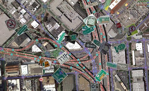
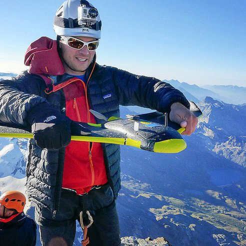
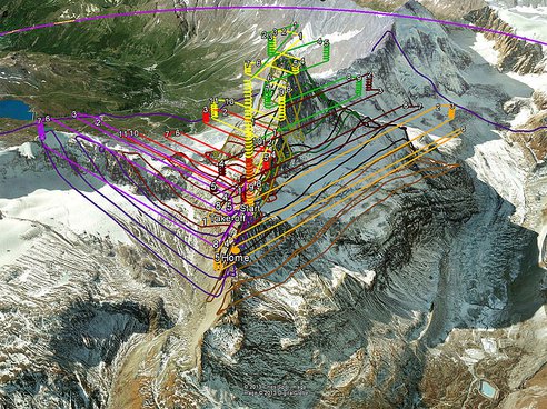
The possible applications for drones are growing every day. From watching out for poachers in wildlife parks in Africa to delivering textbooks to students, the autonomous flying machines are tackling problems both big and small. The ability for the drones to have onboard sensors and HD cameras makes them ideal tools for mapping and surveillance.
Taking that idea to the extreme, engineers from senseFly, partnered with Drone Adventures, Pix4D and Mapbox, were able to create a digital model of the Matterhorn with a 20-cm resolution in three dimensions. Two teams took the company's eBee drones to the mountain with Team 1 hiking to the summit and launching the devices to fly around the top of the peak. Team 2 launched eBees from the bottom of the mountain to cover the lower parts of the mountain.
SenseFly says, "The main challenges successfully overcome were to demonstrate the mapping capabilities of minidrones at a very high altitude and in mountainous terrain where 3D flight planning is essential, all the while coping with the turbulences typically encountered in mountainous environments."
For the project, 11 flights were made totaling 340 minutes. The drones took 2,188 photos and created an HD point-cloud with 3 million datapoints. The company's eMotion2 software provided the ground control for the flights, automatically creating flight paths for the multiple drones.
Google Earth has provided many an office worker with several consecutive hours of procrastination material – “Ooh, there’s my house! And my mum’s house! And my nan’s house!” – and these examples of glitches, curated into one handy Flickr account by Trapcode founder Peder Norrby, are fascinating in their weird digital distortion of landscapes the world over. The glitches aren’t really glitches of course but logical misalignments which occur as a result of texture mapping, when a two-dimensional image is applied to the surface of a three-dimensional model. They’re created by an algorithm, rather than human beings, explaining the oddly dehumanised images they present.
The result of these robots creating maps of the world? Trees melting into houses, bridges bending under the weight of cars that cross them and street corners that resemble the scary red slide from Playworld. Like peeping into a weird, dystopian parallel universe, the images are strangely alluring in their interpretations of the changing representations of the Earth’s surface.
We've seen many of these real-digital glitches, but it is still fascinating. Could possibly become an interesting environment for a new "Inception-like" movie...
Created by Charlie Behrens, this short film is intended to encourage a creative audience to seek out Kevin Slavin’s talk “Those Algorithms Which Govern Our Lives”. It employs an effect which takes place in Google Earth when its 3D street photography and 2D satellite imagery don’t register correctly
*I’m guessing this rig won’t show up on a fashion catwalk any time soon.
Published on Jun 6, 2012 by googlemaps
“There’s a whole wilderness out there that is only accessible by foot. Street View Trekker solves that problem by enabling us to photograph beautiful places such as the Grand Canyon or Muir Woods so anyone can explore them. All the equipment fits in this one backpack.”
It's common when we discuss the future of maps to reference the Borgesian dream of a 1:1 map of the entire world. It seems like a ridiculous notion that we would need a complete representation of the world when we already have the world itself. But to take scholar Nathan Jurgenson's conception of augmented reality seriously, we would have to believe that every physical space is, in his words, "interpenetrated" with information. All physical spaces already are also informational spaces.
Interesting point by author A. C. Madrigal in his article to consider the Google driverless cars as the coming "web crawlers" of the physical world ... Interesting also, the concept of "deep map".
Additionnal comment on this post (01.10.2012), even more interesting now that we see Google driverless cars getting legalized in California...
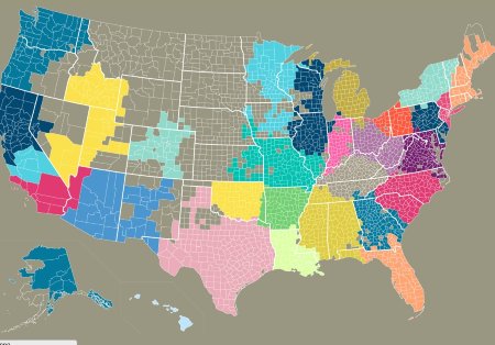
This is what our state lines might look like if we drew them based on who actually talks with each other, at least according to cell phone data gathered by MIT. These are the geographic clusters of who texts with whom within an area, from the MIT Senseable City Lab's Connected States of America mapping project.
If volume of communication determined state lines, New York City would break ranks with the state that shares its name and join up with oft-maligned New Jersey. Mississippi and Alabama would merge, so would most of New England. Wisconsin would split in two to join Illinois and Minnesota.
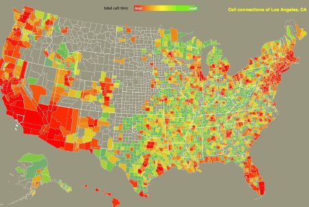
But one can also look at how a given regions talk with other regions, and how close those ties are, distance factored in. The map below is of Los Angeles' connections to the rest of the country. Red areas are those with the most connections to L.A. according to cell phone conversations.
The Connected States of America project's interactive maps and visualizations show us how different parts of the country interact, and raise the question, what is a community? There was a simple answer 60 years ago when geography determined who you talked with, bonded with, and spent your life with. Now that families are scattered across the country for college, jobs, or wanderlust, and companies set up bi-coastal offices without a second thought, that's no longer true. Should we care that the people we're most connected with aren't necessarily nearby?
Play around with the maps at MIT's site. For a little inspiration, watch this short video.
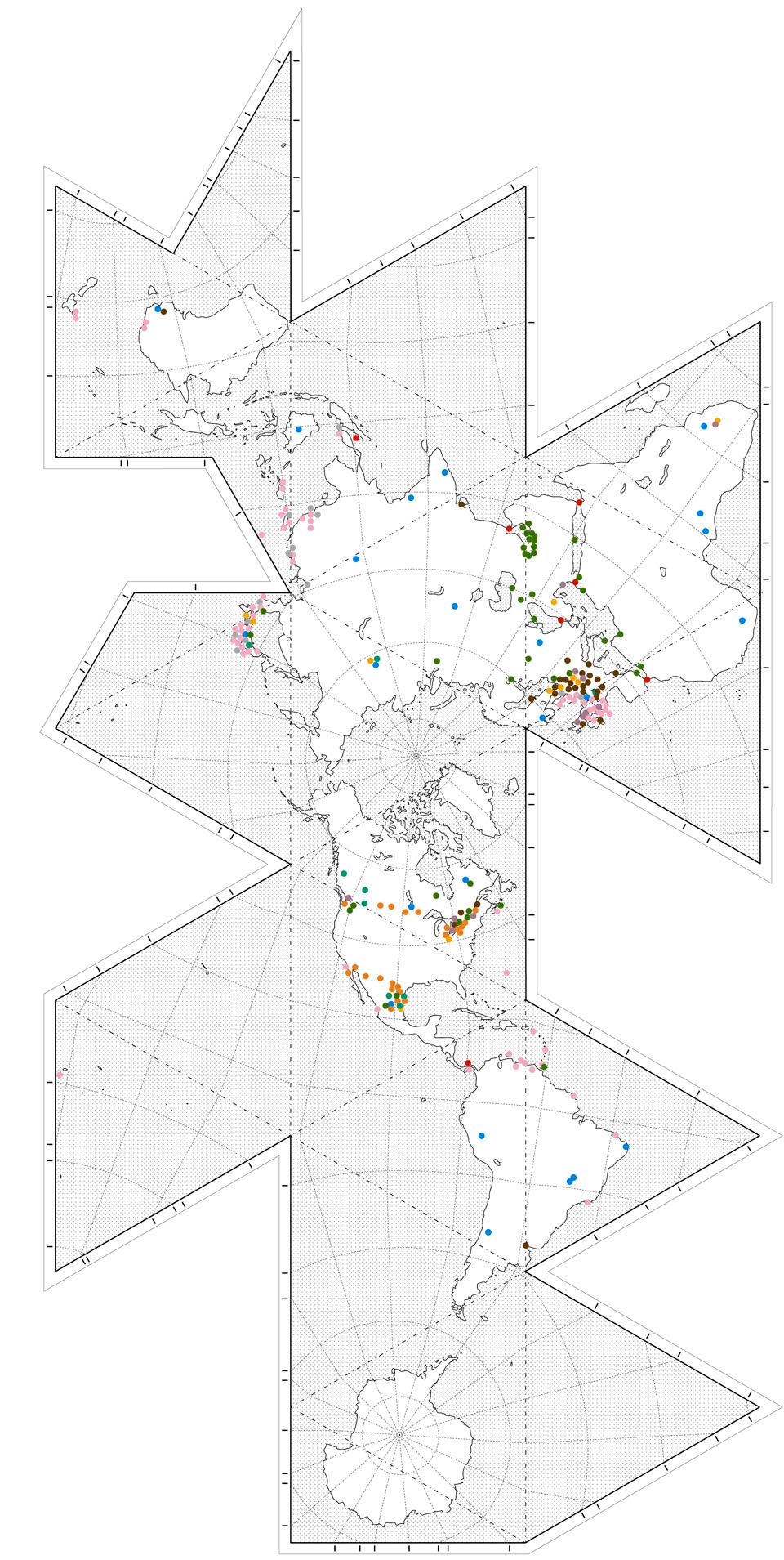
A recent article of mine for Domus, on the "critical foreign dependencies" list revealed last winter by Wikileaks, is now online, in case you missed it here, complete with some maps and infographics.
[Image: Map by, and courtesy of, Domus, "in homage to Buckminster Fuller’s famous Dymaxion projection, and showing the locations of 259 critical infrastructures"; see it folded up, courtesy of David M.A.].
Check it out if you get a chance—and thanks again to Domus for the opportunity to explore this topic.
Personal comment:
Beside the topic that tells us that a country as a lot of distributed crucial interests outside its own borders, which modifies the idea of nation's territory, I also like the fact that it is shown on Buckminster Fuller's map that describes an Earth made out of connected and nearly continuous lands and archipelagoes, connected through the Arctic...
[A NASA visualization of the 1993 summer wind patterns that caused that year's Mississippi floods:
"The arrows indicate wind trajectories, while color indicates wind height. The length of a line equates to wind speed (stronger winds get longer lines). Black arrows trace the low-altitude winds that carry moisture, the winds most relevant to the 1988 drought and 1993 floods. These winds are about 1,500 meters (4,900 feet, 850 millibars) above the surface. White arrows are winds at 5,400 meters (18,000 ft, 500 mb), and blue arrows are high-altitude winds at about 9.2 kilometers (30,000 ft, 300 mb)."]
[For comparison, winds from the same period (the beginning of May to the end of July) in 1988, a year of drought that also devastated the Midwest, but in opposite fashion. Note that in 1993, the high-pressure, low-altitude winds (black arrows) flow freely up from the Gulf of Mexico, bringing moisture-laden air to the Midwest, while in the 1988, a high-pressure system hovered over the Midwest, pushing air south and blocking movement of moist air from the Gulf of Mexico. To really appreciate the difference, you'll want to watch the animated versions -- 1988 here and 1993 here. (Note those links are to download sizable video files.)]
Beautiful evolving wind geographies and wind maps (weather data) by NASA (even if in this case, they are about catastrophic weather events).
This presents to me a totally different geography of Earth, invisible indeed (but not all the times, think of course about clouds, ligntnings, wind in trees and high grass or storms, etc.), but effective and highly variable over time.
In 1942, after the United States entered the second world war and fearing the Japanese threat on the Pacific coast, an entire aircraft plant and airport -the Lockheed Burbank- has been camouflaged to escape from sight to potential Japanese airplanes. It is interesting to observe that, in order to do so, the US army had to ask for the help of Hollywood studios -WWII is probably the beginning of a long history of exchanges between Hollywood and the US Army- to make this industrial landscape appearing as a piece of suburbia. The very vast aircraft plant was therefore obliged to function under a porous canopy from which was emerging here and there, some chimneys disguised in trees or fountains.
This blog is the survey website of fabric | ch - studio for architecture, interaction and research.
We curate and reblog articles, researches, writings, exhibitions and projects that we notice and find interesting during our everyday practice and readings.
Most articles concern the intertwined fields of architecture, territory, art, interaction design, thinking and science. From time to time, we also publish documentation about our own work and research, immersed among these related resources and inspirations.
This website is used by fabric | ch as archive, references and resources. It is shared with all those interested in the same topics as we are, in the hope that they will also find valuable references and content in it.


")