Wednesday, February 18. 2015
World Brain: a journey through data centers | #data #dimensions
Via iiclouds.org (Nicolas Nova)
-----
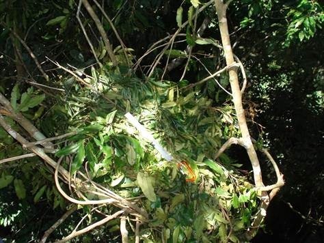
“World Brain” by Stéphane Degoutin and Gwenola Wagon (2015):
World Brain proposes a stroll through motley folkloric tales : data centers, animal magnetism, the Internet as a myth, the inner lives of rats, how to gather a network of researchers in the forest, how to survive in the wild using Wikipedia, how to connect cats and stones…
The world we live in often resembles a Borgesian story. Indeed, if one wanted to write a sequel to Borges’ Fictions, he could do it simply by putting together press articles.
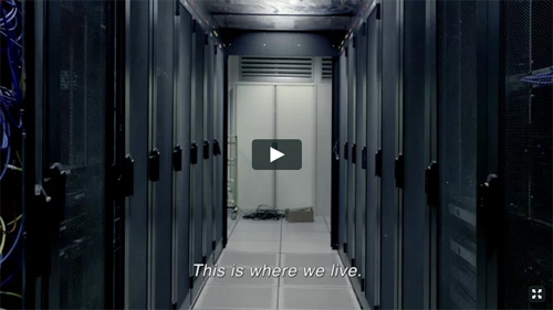
The World Brain is made out mostly of found materials : videos downloaded on Youtube, images, scientific or pseudo scientific reports, news feeds… [...] World Brain takes the viewer through a journey inside the physical places by which the Internet transits: submarine cables, data centers, satellites. The film adopts the point of view of the data. The audience view the world as if they were information, crossing the planet in an instant, copied in an infinite number of instances or, at the contrary, stored in secret places.
Sunday, February 01. 2015
Deterritorialized House - Inhabiting the data center, 2014 sketches... | #data #decenter #housing
By fabric | ch
-----
Along different projects we are undertaking at fabric | ch, we continue to work on self initiated researches and experiments (slowly, way too slowly... Time is of course missing). Deterritorialized House is one of them, introduced below.
Some of these experimental works concern the mutating "home" program (considered as "inhabited housing"), that is obviously an historical one for architecture but that is also rapidly changing "(...) under pressure of multiple forces --financial, environmental, technological, geopolitical. What we used to call home may not even exist anymore, having transmuted into a financial commodity measured in sqm (square meters)", following Joseph Grima's statement in sqm. the quantified home, "Home is the answer, but what is the question?"
In a different line of works, we are looking to build physical materializations in the form of small pavilions for projects like i.e. Satellite Daylight, 46°28'N, while other researches are about functions: based on live data feeds, how would you inhabit a transformed --almost geo-engineered atmospheric/environmental condition? Like the one of Deterritorialized Living (night doesn't exist in this fictional climate that consists of only one day, no years, no months, no seasons), the physiological environment of I-Weather, or the one of Perpetual Tropical Sunshine, etc.?
We are therefore very interested to explore further into the ways you would inhabit such singular and "creolized" environments composed of combined dimensions, like some of the ones we've designed for installations. Yet considering these environments as proto-architecture (architectured/mediated atmospheres) and as conditions to inhabit, looking for their own logic.
We are looking forward to publish the results of these different projects along the year. Some as early sketches, some as results, or both. I publish below early sketches of such an experiment, Deterritorialized House, linked to the "home/house" line of research. It is about symbiotically inhabiting the data center... Would you like it or not, we surely de-facto inhabit it, as it is a globally spread program and infrastructure that surrounds us, but we are thinking here in physically inhabiting it, possibly making it a "home", sharing it with the machines...
What is happening when you combine a fully deterritorialized program (super or hyper-modern, "non lieu", ...) with the one of the home? What might it say or comment about contemporary living? Could the symbiotic relation take advantage of the heat the machine are generating --directly connected to the amount of processing power used--, the quality of the air, the fact that the center must be up and running, possibly lit 24/7, etc.
As we'll run a workshop next week in the context of another research project (Inhabiting and Interfacing the Cloud(s), an academic program between ECAL, HEAD, EPFL-ECAL Lab and EPFL in this case) linked to this idea of questioning the data center --its paradoxically centralized program, its location, its size, its functionalism, etc.--, it might be useful to publish these drawings, even so in their early phase (theys are dating back from early 2014, the project went back and forth from this point and we are still working on it.)
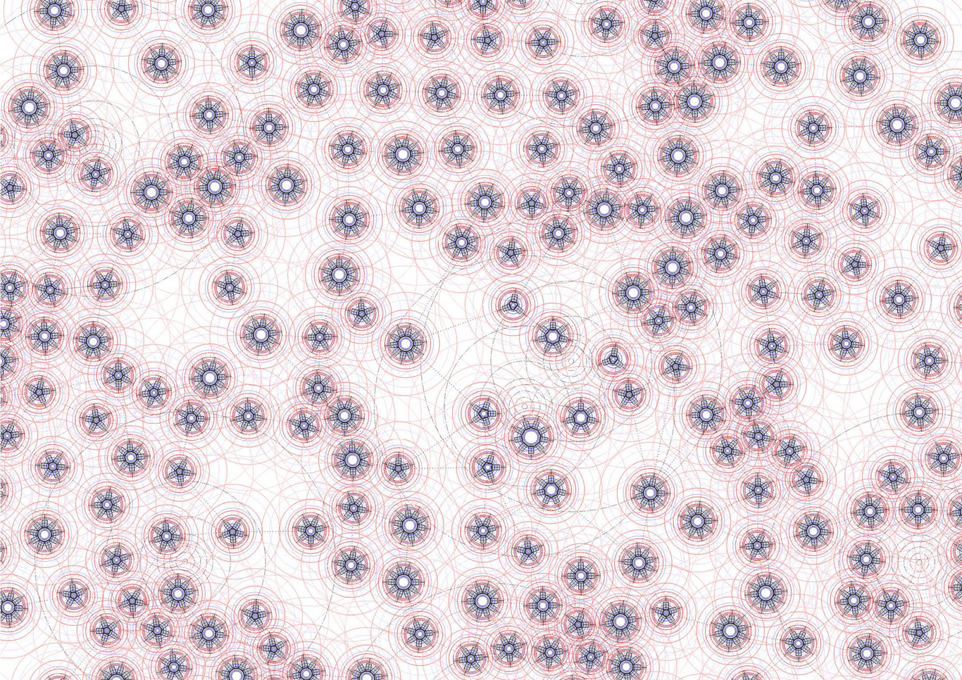
1) The data center level (level -1 or level +1) serves as a speculative territory and environment to inhabit (each circle in this drawing is a fresh air pipe sourrounded by a certain number of computers cabinets --between 3 and 9).
A potential and idealistic new "infinite monument" (global)? It still needs to be decided if it should be underground, cut from natural lighting or if it should be fragmented into many pieces and located in altitude (--likely, according to our other scenarios that are looking for decentralization and collaboration), etc. Both?
Fresh air is coming from the outside through the pipes surrounded by the servers and their cabinets (the incoming air could be an underground cooled one, or the one that can be found in altitude, in the Swiss Alps --triggering scenarios like cities in the moutains? moutain data farming? Likely too, as we are looking to bring data centers back into small or big urban environments). The computing and data storage units are organized like a "landscape", trying to trigger different atmospheric qualities (some areas are hotter than others with the amount of hot air coming out of the data servers' cabinets, some areas are charged in positive ions, air connectivity is obviously everywhere, etc.)
Artificial lighting follows a similar organization as the servers' cabinets need to be well lit. Therefore a light pattern emerges as well in the data center level. Running 24/7, with the need to be always lit, the data center uses a very specific programmed lighting system: Deterritorialized Daylight linked to global online data flows.

2) Linked to the special atmospheric conditions found in this "geo-data engineered atmosphere" (the one of the data center itself, level -1 or 1), freely organized functions can be located according to their best matching location. There are no thick walls as the "cabinets islands" acts as semi-open partitions.
A program starts to appear that combines the needs of a data center and the one of a small housing program which is immersed into this "climate" (dense connectivity, always artificially lit, 24°C permanent heat). "Houses" start to appear as "plugs" into a larger data center.
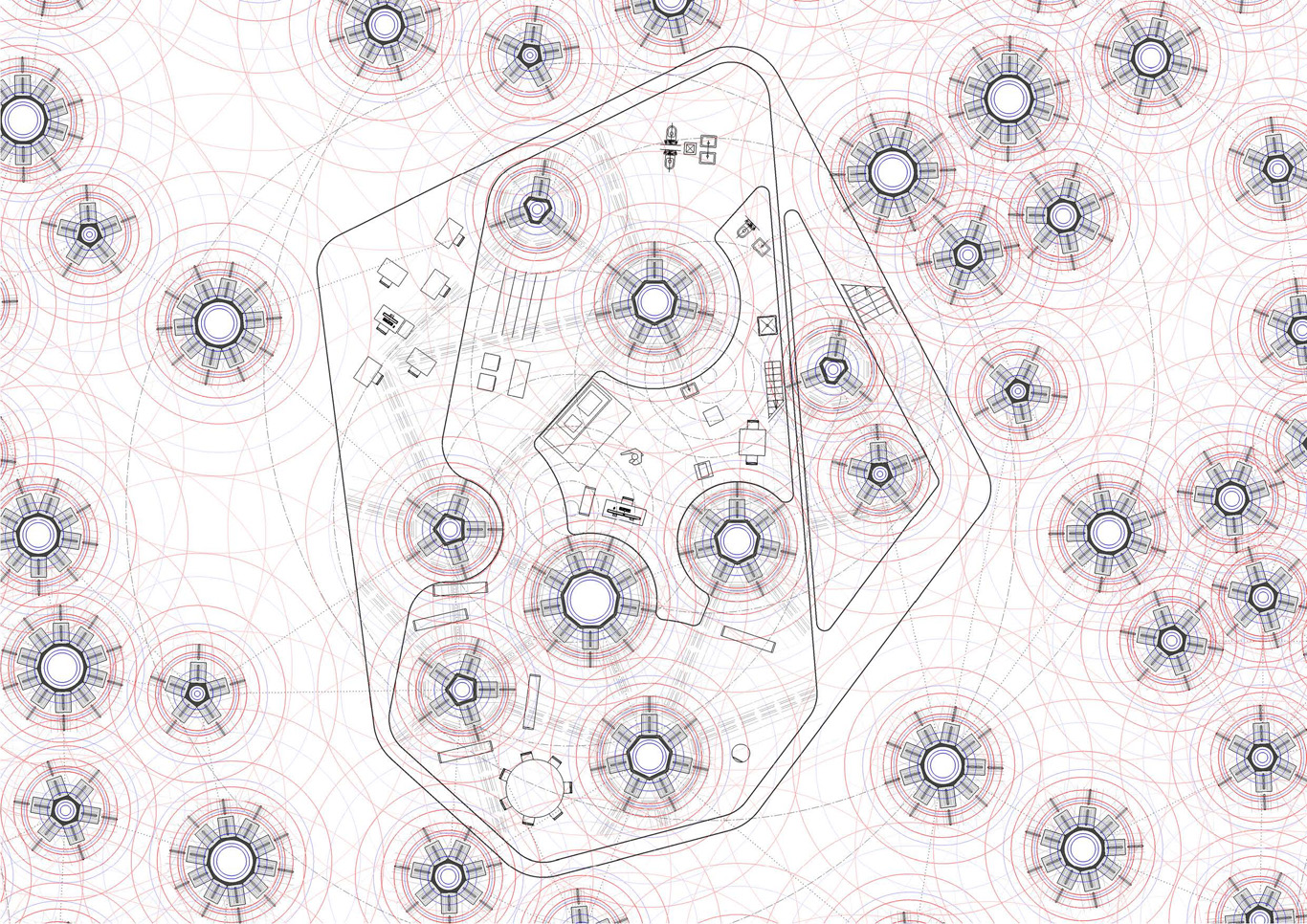
3) A detailed view (data center, level -1 or +1) on the "housing plug" that combine programs. At this level, the combination between an office-administration unit for a small size data center start to emerge, combined with a kind of "small office - home office" that is immersed into this perpetually lit data space. This specific small housing space (a studio, or a "small office - home office") becomes a "deterritorialized" room within a larger housing program that we'll find on the upper level(s), likely ground floor or level +2 of the overall compound.
4) Using the patterns emerging from different spatial components (heat, light, air quality --dried, charged in positive ions--, wifi connectivity), a map is traced and "moirés" patterns of spatial configurations ("moirés spaces") start to happen. These define spatial qualities. Functions are "structurelessly" placed accordingly, on a "best matching location" basis (needs in heat, humidity, light, connectivity which connect this approach to the one of Philippe Rahm, initiated in a former research project, Form & Function Follow Climate (2006). Or also i.e. the one of Walter Henn, Burolandschaft (1963), if not the one of Junya Ishigami's Kanagawa Institute).
Note also that this is a line of work that we are following in another experimental project at fabric | ch, about which we also hope to publish along the year, Algorithmic Atomized Functioning --a glimpse of which can be seen in Desierto Issue #3, 28° Celsius.
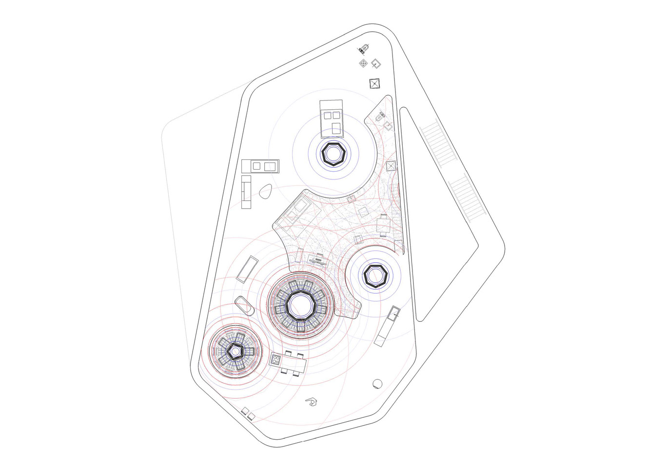
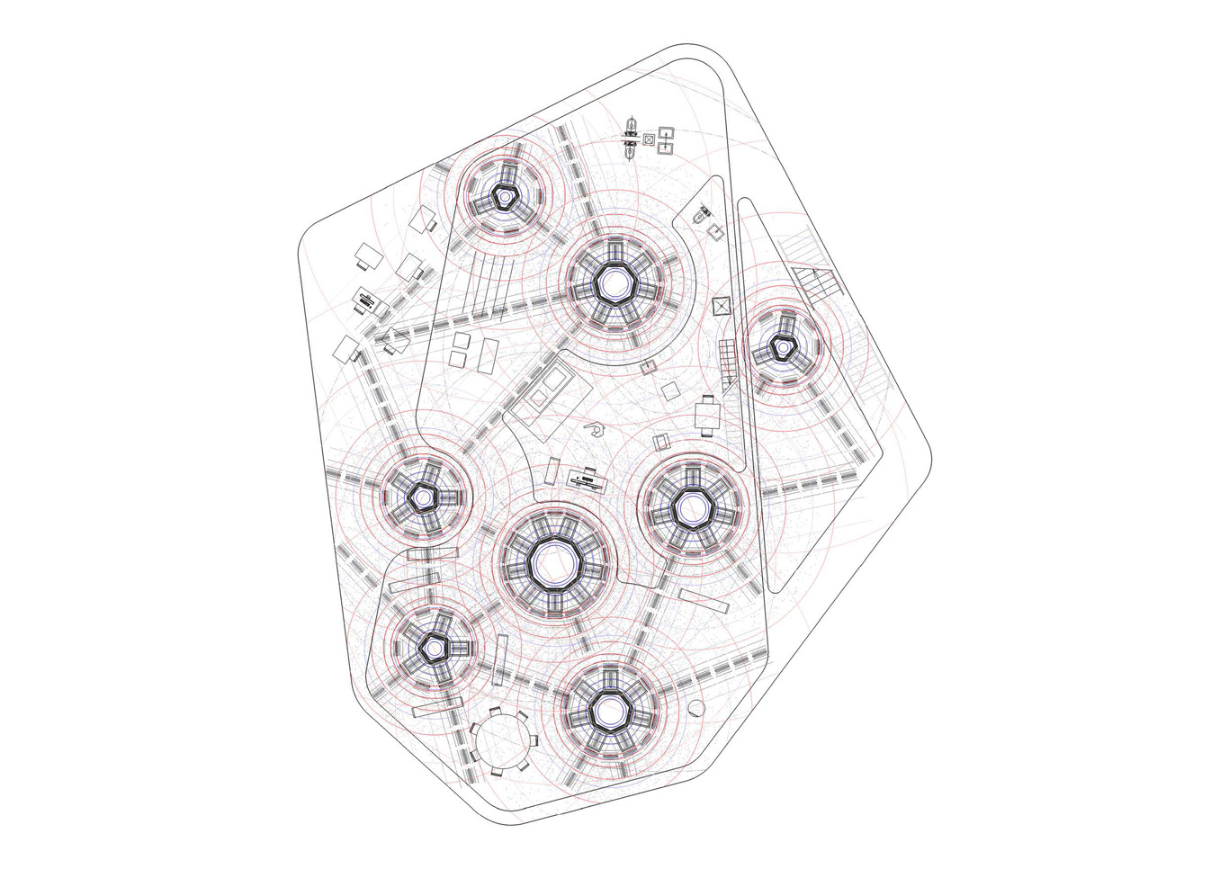
5) On ground level or on level +2, the rest of the larger house program and few parts of the data center that emerges. There are no other heating or artificial lighting devices besides the ones provided by the data center program itself. The energy spent by the data center must serve and somehow be spared by the house. Fresh and hot zones, artificial light and connectivity, etc. are provided by the data center emergences in the house, so has from the opened "small office - home office" that is located one floor below. Again, a map is traced based and moirés patterns of specific locations and spatial configurations emerge. Functions are also placed accordingly (hot, cold, lit, connected zones).
Starts or tries to appear a "creolized" housing object, somewhere in between a symbiotic fragmented data center and a house, possibly sustaining or triggering new inhabiting patterns...
--------------------------------
Project (ongoing): fabric | ch
Team: Patrick Keller, Christophe Guignard, Christian Babski, Sinan Mansuroglu
Friday, January 23. 2015
Inhabiting and Interfacing the Cloud(s) Talk & workshop at LIFT 15
Note: Following my recent posts about the research project "Inhabiting & Intercacing the Cloud(s)" I'm leading for ECAL, Nicolas Nova and I will be present during next Lift Conference in Geneva (Feb. 4-6 2015) for a talk combined with a workshop and a skype session with EPFL (a workshop related to the I&IC research project will be on the finish line at EPFL –Prof. Dieter Dietz’s ALICE Laboratory– on the day we’ll present in Geneva). If you plan to take part to Lift 15, please come say "hello" and exchange about the project.
Via the Lift Conference & iiclouds.org
—–
Inhabiting and Interfacing the Cloud(s)


Workshop description : Since the end of the 20th century, we have been seeing the rapid emergence of “Cloud Computing”, a new constructed entity that combines extensively information technologies, massive storage of individual or collective data, distributed computational power, distributed access interfaces, security and functionalism.
In a joint design research that connects the works of interaction designers from ECAL & HEAD with the spatial and territorial approaches of architects from EPFL, we’re interested in exploring the creation of alternatives to the current expression of “Cloud Computing”, particularly in its forms intended for private individuals and end users (“Personal Cloud”). It is to offer a critical appraisal of this “iconic” infrastructure of our modern age and its user interfaces, because to date their implementation has followed a logic chiefly of technical development, governed by the commercial interests of large corporations, and continues to be seen partly as a purely functional,centralized setup. However, the Personal Cloud holds a potential that is largely untapped in terms of design, novel uses and territorial strategies.
The workshop will be an opportunity to discuss these alternatives and work on potential scenarios for the near future. More specifically, we will address the following topics:
- How to combine the material part with the immaterial, mediatized part? Can we imagine the geographical fragmentation of these setups?
- Might new interfaces with access to ubiquitous data be envisioned that take nomadic lifestyles into account and let us offer alternatives to approaches based on a “universal” design? Might these interfaces also partake of some kind of repossession of the data by the end users?
- What setups and new combinations of functions need devising for a partly nomadic lifestyle? Can the Cloud/Data Center itself be mobile?
- Might symbioses also be developed at the energy and climate levels (e.g. using the need to cool the machines, which themselves produce heat, in order to develop living strategies there)? If so, with what users (humans, animals, plants)?
The joint design research Inhabiting & Interfacing the Cloud(s) is supported by HES-SO, ECAL & HEAD.
Interactivity : The workshop will start with a general introduction about the project, and moves to a discussion of its implications, opportunities and limits. Then a series of activities will enable break-out groups to sketch potential solutions.
Wednesday, December 24. 2014
EmTech: Googles Internet Loon Balloons Will Ring the Globe within a Year | #atmosphere
Note: Google Earth or literally and progressively Google's Earth? It could also be considered as the start of the privatization of the lower stratosphere, where up to now, no artifacts were permanently present.
-----
Google X research lab boss Astro Teller says experimental wireless balloons will test delivering Internet access throughout the Southern Hemisphere by next year.
By Tom Simonite

Astro Teller & a Project Loon prototype sails skyward.
Within a year, Google is aiming to have a continuous ring of high-altitude balloons in the Southern Hemisphere capable of providing wireless Internet service to cell phones on the ground.
That’s according to Astro Teller, head of the Google X lab, the company established with the purpose of working on “moon shot” research projects. He spoke at MIT Technology Review’s EmTech conference in Cambridge today.
Teller said that the balloon project, known as Project Loon, was on track to meet the goal of demonstrating a practical way to get wireless Internet access to billions of people who don’t have it today, mostly in poor parts of the globe.
For that to work, Google would need a large fleet of balloons constantly circling the globe so that people on the ground could always get a signal. Teller said Google should soon have enough balloons aloft to prove that the idea is workable. “In the next year or so we should have a semi-permanent ring of balloons somewhere in the Southern Hemisphere,” he said.
Google first revealed the existence of Project Loon in June 2013 and has tested Loon Balloons, as they are known, in the U.S., New Zealand, and Brazil. The balloons fly at 60,000 feet and can stay aloft for as long as 100 days, their electronics powered by solar panels. Google’s balloons have now traveled more than two million kilometers, said Teller.
The balloons provide wireless Internet using the same LTE protocol used by cellular devices. Google has said that the balloons can serve data at rates of 22 megabits per second to fixed antennas, and five megabits per second to mobile handsets.
Google’s trials in New Zealand and Brazil are being conducted in partnership with local cellular providers. Google isn’t currently in the Internet service provider business—despite dabbling in wired services in the U.S. (see “Google Fiber’s Ripple Effect”)—but Teller said Project Loon would generate profits if it worked out. “We haven’t taken a dime of revenue, but if we can figure out a way to take the Internet to five billion people, that’s very valuable,” he said.
Related Links:
Friday, October 24. 2014
Celestial Chiaroscuro | #visiblesignal
Via BLDGBLOG
-----
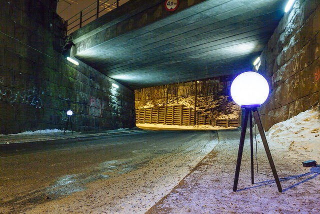
Immaterials: Satellite Lamps from Satellite Lamps on Vimeo.
An interesting new project called Satellite Lamps, by Einar Sneve Martinussen, Jørn Knutsen, and Timo Arnall, attempts to visualize the ever-drifting, never exactly accurate workings of GPS.
As the above video shows, the project uses "a set of lamps that contain GPS receivers, that change brightness according to the accuracy of received GPS signals. When we photograph them in timelapse, they reveal how the accuracy changes over time."
You're basically watching the indirect effects of signal drift, transformed here into ambient mood lighting that acts secondarily as a graph of celestial geography.

[Image: From Satellite Lamps].
In what the group calls a "selective history of how a piece of the Space Program has ended up in our pockets," they explain that the everyday reception of signals coming down from the constellation of GPS satellites is always subject to temporary errors, inaccuracies, and misalignments; this can be seen easily enough by glancing at nothing more than your own physical location, as mapped on your cell phone.
They also point to an interesting observation, made by artist James Bridle, that "if you leave a running app such as Nike+ or Runkeeper on your bedside table while you sleep at night, you will wake up to see that the app reports that you ran a significant distance, without doing anything. This, we speculated, is due to the way in which these apps are recording the GPS inaccuracies and counting these as actual, physical movements. In reality, these odd asymmetrical star-shaped tracks offer a map of the shifts of the phone attempting to locate itself."
This ghostly movement is not "real" in any spatial or geographic sense, but it nonetheless leaves digital tracks in our information profiles, like phantom trips being taken by our data-shadows in secret.

[Image: From Satellite Lamps].
So why not visualize this ongoing slippage—these minor tectonics events taking place inside the tools of geography—in a different form, not with, say, an iPhone scooting around all over your neighborhood at night, trying to keep up with the haunted midnight fugues of an errant running app, but with something stationary, something all the more uncanny for the invisible movements that seem to pass through it like an aurora?
This, then, is the point of Satellite Lamps, which flicker and dim to help reveal the invisible glitches in earth-to-satellite coordination, paradoxically unmoving chandeliers that shine in a chiaroscuro of side-effects leaking in from a parallel world.
[Image: From Satellite Lamps].
In any case, the project is voluminously explained and documented. Considering reading about GPS itself, about the team's strategy for giving visual form to invisible information, and, finally, about the physical realization of the lamps.
Wednesday, October 15. 2014
Town Built for Driverless Cars | #automated
Note: after the zoning for drones within cities, will we develop them with specific "city marks" dedicated for driverless cars? It reminds me a bit of this design research project done a few years ago, The New Robot Domesticity, which purpose was to design objects so that robots could also recognized/use them. Further away, it also remind me of a workshop we organized at the ECAL back in 2005 with researcher Frederic Kaplan (now head of Digital Humanities at EPFL) which purpose was to design artefacts for the Sony Aibo (a doc. video here). This later prtoject was realized in the frame of the research project Variable Environment.
-----
Tricky intersections and rogue mechanical pedestrians will provide a testing area for automated and connected cars.
By Will Knight
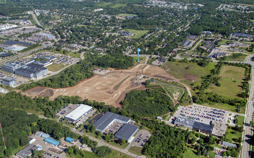
The site of Ann Arbor’s driverless town, currently under construction.
A mocked-up set of busy streets in Ann Arbor, Michigan, will provide the sternest test yet for self-driving cars. Complex intersections, confusing lane markings, and busy construction crews will be used to gauge the aptitude of the latest automotive sensors and driving algorithms; mechanical pedestrians will even leap into the road from between parked cars so researchers can see if they trip up onboard safety systems.
The urban setting will be used to create situations that automated driving systems have struggled with, such as subtle driver-pedestrian interactions, unusual road surfaces, tunnels, and tree canopies, which can confuse sensors and obscure GPS signals.
“If you go out on the public streets you come up against rare events that are very challenging for sensors,” says Peter Sweatman, director of the University of Michigan’s Mobility Transformation Center, which is overseeing the project. “Having identified challenging scenarios, we need to re-create them in a highly repeatable way. We don’t want to be just driving around the public roads.”
Google and others have been driving automated cars around public roads for several years, albeit with a human ready to take the wheel if necessary. Most automated vehicles use accurate digital maps and satellite positioning, together with a suite of different sensors, to navigate safely.
Highway driving, which is less complex than city driving, has proved easy enough for self-driving cars, but busy downtown streets—where cars and pedestrians jockey for space and behave in confusing and surprising ways—are more problematic.
“I think it’s a great idea,” says John Leonard, a professor at MIT who led the development of a self-driving vehicle for a challenge run by DARPA in 2007. “It is important for us to try to collect statistically meaningful data about the performance of self-driving cars. Repeated operations—even in a small-scale environment—can yield valuable data sets for testing and evaluating new algorithms.”
The simulation is being built on the edge of the University of Michigan’s campus with funding from the Michigan Department of Transportation and 13 companies involved with developing automated driving technology. It is scheduled to open next spring. It will consist of four miles of roads with 13 different intersections.
Even Google, which has an ambitious vision of vehicle automation, acknowledges that urban driving is a significant challenge. Speaking at an event in California this July, Chris Urmson, who leads the company’s self-driving car project, said several common urban situations remain thorny (see “Urban Jungle a Tough Challenge for Google’s Autonomous Car”). Speaking with MIT Technology Review last month, Urmson gave further details about as-yet-unsolved scenarios (see “Hidden Obstacles for Google’s Self-Driving Cars”).
Such challenges notwithstanding, the first automated cars will go into production shortly. General Motors announced last month that a 2017 Cadillac will be the first car to offer entirely automated driving on highways. It’s not yet clear how the system will work—for example, how it will ensure that the driver isn’t too distracted to take the wheel in an emergency, or under what road conditions it might refuse to take the wheel—but in some situations, the car’s Super Cruise system will take care of steering, braking, and accelerating. Another technology to be tested in the simulated town is vehicle-to-vehicle communications. The University of Michigan recently concluded a government-funded study in Ann Arbor involving thousands of vehicles equipped with transmitters that broadcast position, direction of travel, speed, and other information to other vehicles and to city infrastructure. The trial showed that vehicle-to-vehicle and vehicle-to-infrastructure communications could prevent many common accidents by providing advanced warning of a possible collision. “One of the interesting things, from our point of view, is what extra value you get by combining” automation and car-to-car communications, Sweatman says. “What happens when you put the two together—how much faster can you deploy it?”
Saturday, August 02. 2014
This secret swimming pool in the Mojave desert could be all yours... | #gps
Note: in the end... it's time for me (too) to turn off my screens for a couple of weeks and maybe go look for this swimming pool! "Subjective collections of ..." and myself will be back in early September.
Via Archinect
-----
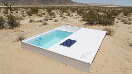
The piece was completed last Friday and it consists of a single, diminutive swimming pool located somewhere in the southern Mojave Desert between Joshua Tree and Apple Valley. The public is allowed to use the pool, but in order to do so visitors need the key that unlocks it (it is kept covered) as well as the GPS coordinates. Only once you have the key, which is kept at the MAK Center, are you given the coordinates.
Thursday, July 31. 2014
(Un)natural Architectures: Scorpion Design Temperature-Controlled Burrows | #habitat
Via Archinect
-----
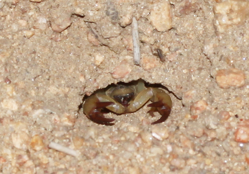
Scientists have discovered that scorpions design their burrows to include both hot and cold spots. A long platform provides a sunny place to warm up before they hunt, whilst a humid chamber acts as a cool refuge during the heat of the day.
This recent discovery of scorpion architecture adds to a sizeable list of impressive non-human architecture.
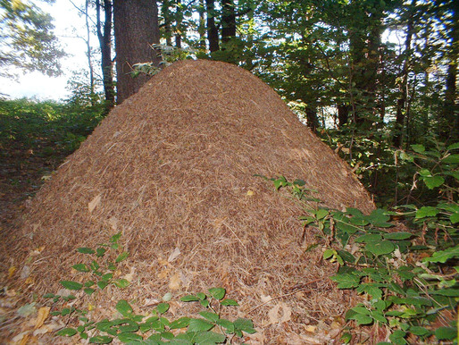
Anthills consist of a complex network of paths. Comparative to the size of an individual ant, these structures are mega-skyscrapers.

Likewise, termites build huge structures that have been dubbed "cathedrals." Reaching up to 6m high or more, termite cathedrals are clustered in large arrays that cover whole landscapes.
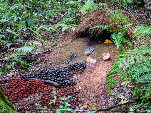
This complex web of branches was built by the vogelkop gardener bowerbird. In direct refutation of the "less is more" aesthetic exemplified by both ants and Ludwig Mies van der Rohe, these birds embellish their structures with any bright things they can find.
Primates, including humans, are probably the most avid builders. For example, from an early age, orangutans learn to design and construct elaborately woven nests high in trees.
Far from trivial – and humor aside –, studying animal architectures helps destabilize the normative understanding of architecture as a strictly human domain of activity. Certain studios – like Animal Architecture – both draw inspiration from non-human design and develop collaborative practices with non-humans. Decentering the human as the center of architectural thinking is a necessary step in fostering a deeper understanding of the complex mesh of interconnectedness that is ecology. Without this step, humans will continue to practice architecture without regard for a larger context, which is why the profession already accounts for nearly half of US carbon emissions.
Monday, June 30. 2014
Balloon-Powered Internet For Everyone | #atmosphere #network
Note: I've already collected articles about this project, which interestingly, would add a permanent human presence in a layer of the atmosphere (the statosphere) where humans were not or very rarely present up to now. We also have to underline the fact that this will be an additionnal move toward the "brandification/privatization" (of the upper levels of our atmosphere --stratosphere, thermosphere-- and outer space).
It is interesting indeed, with clever worlds like "bringing the internet to million of people". Yet some other ones have a more critical view upon this strategic move by corporate interests: read Google Eyes in the Sky (by Will Oremus on Slate)
Via Next Nature
-----

Balloon-Powered Internet For Everyone
Both Google and Facebook have challenging intentions to bring the Internet to the next billion people, and while Zuckerberg’s dream involves drones with lasers, Google is planning to create a hot air balloon network.
With a system of balloons traveling on the edge of space, Project Loon will attempt to connect to internet the two-thirds of the world’s population that doesn’t have access to the Net. The balloons will float in the stratosphere, twice as high as airplanes and the weather. Users can connect to the network using a specific Internet antenna attached to their building.
“Project Loon uses software algorithms to determine where its balloons need to go, then moves each one into a layer of wind blowing in the right direction. By moving with the wind, the balloons can be arranged to form one large communications network” is explained on Project Loon website.
Currently, Google is still in the testing phase to learn more about wind patterns, and improve the balloons design. A step toward universal Internet connection?
Find more at Project Loon
Related Links:
fabric | rblg
This blog is the survey website of fabric | ch - studio for architecture, interaction and research.
We curate and reblog articles, researches, writings, exhibitions and projects that we notice and find interesting during our everyday practice and readings.
Most articles concern the intertwined fields of architecture, territory, art, interaction design, thinking and science. From time to time, we also publish documentation about our own work and research, immersed among these related resources and inspirations.
This website is used by fabric | ch as archive, references and resources. It is shared with all those interested in the same topics as we are, in the hope that they will also find valuable references and content in it.
Quicksearch
Categories
Calendar
|
|
April '24 | |||||
| Mon | Tue | Wed | Thu | Fri | Sat | Sun |
| 1 | 2 | 3 | 4 | 5 | 6 | 7 |
| 8 | 9 | 10 | 11 | 12 | 13 | 14 |
| 15 | 16 | 17 | 18 | 19 | 20 | 21 |
| 22 | 23 | 24 | 25 | 26 | 27 | 28 |
| 29 | 30 | |||||
