Taken out from a post (Lemonade Igloo, salt deserts and other landscape wonders) by Régine Debatty about the work of photographer Scarlett Hooft Gaafland on WMMNA, this lemonade house make me think of houses that you could eventually drink before you move... providing the inhabitant with some sort of "house" nutrient...
As a reminder as well of some vernacular, farm type of architectures in the Alps, when in winter everything was in close(d) circuitry: the animals --mostly cows-- were living in the lower level of the house producing heat for the inhabitants, while also producing food. Inhabitants, animals and architecture were in a sort of symbiotic relationship.
Field test by British academics marks first step towards recreating an artificial volcano that would inject particles into the stratosphere and cool the planet
It sounds barmy, audacious or sci-fi: a tethered balloon the size of Wembley stadium suspended 20km above Earth, linked to the ground by a giant garden hose pumping hundreds of tonnes of minute chemical particles a day into the thin stratospheric air to reflect sunlight and cool the planet.
But a team of British academics will next month formally announce the first step towards creating an artificial volcano by going ahead with the world's first major "geo-engineering" field-test in the next few months. The ultimate aim is to mimic the cooling effect that volcanoes have when they inject particles into the stratosphere that bounce some of the Sun's energy back into space, so preventing it from warming the Earth and mitigating the effects of man-made climate change.
Hacking the planet - potential geo-engineering solutions
Ocean nourishment
Billions of iron filings are deposited in the ocean to stimulate a phytoplankton bloom. The aim is to enhance biological productivity to remove carbon dioxide from the atmosphere. Many experiments have been conducted, including fertilisation of 900 square kilometers (350 sq miles) of the Atlantic. Results so far are disappointing.
Space mirrors
Giant "mirrors", made of wire mesh, could be sent into in orbit to deflect sunlight back into space. But the scale needed, the expense and the potential unintended consequences are so great that it is widely considered unrealistic. In the same league as the idea to mine the moon to create a shielding cloud of dust.
Cloud whitening
The idea is to increase the water content in low clouds by spraying sea water at them. This makes them reflect more sunlight. It would be pretty harmless, and cheap but would have to be done on an immense scale to have any global effect. Backed by Bill Gates.
Artificial trees
Proposed by climate scientist Wallace Broecker who imagines 60m artificial "trees" dotted around the world, "scrubbing" the air by capturing CO2 in a filter and then storing it underground. The trees could remove more carbon dioxide than an equivalent-sized real tree.
Carbon dioxide is collected from coal or other fossil fuel power plants and is then pumped underground. Works in principle but it is expensive and increases the fuel needs of a coal-fired plant by 25%-40%. More than 40 plants have been built with many others planned.
Manhattanhenge, is the term used to describe a biannual occurrence in New York City when the sun aligns with the east-west streets of Manhattan’s main grid. Adopted in 1811 the famous street grid of Manhattan, the Commissioners’ Plan, was the original design plan for the streets in which the grid plan is offset at 29.0 degrees from true east-west. Twice a year photographers gather to witness this urban solar phenomenon, when the sun sets perfectly between the skyscraper corridors and illuminates the north-south facades of the streets. Tripods and pedestrians filled the crosswalks this past Wednesday to catch a glimpse of this moment.
[A NASA visualization of the 1993 summer wind patterns that caused that year's Mississippi floods:
"The arrows indicate wind trajectories, while color indicates wind height. The length of a line equates to wind speed (stronger winds get longer lines). Black arrows trace the low-altitude winds that carry moisture, the winds most relevant to the 1988 drought and 1993 floods. These winds are about 1,500 meters (4,900 feet, 850 millibars) above the surface. White arrows are winds at 5,400 meters (18,000 ft, 500 mb), and blue arrows are high-altitude winds at about 9.2 kilometers (30,000 ft, 300 mb)."]
[For comparison, winds from the same period (the beginning of May to the end of July) in 1988, a year of drought that also devastated the Midwest, but in opposite fashion. Note that in 1993, the high-pressure, low-altitude winds (black arrows) flow freely up from the Gulf of Mexico, bringing moisture-laden air to the Midwest, while in the 1988, a high-pressure system hovered over the Midwest, pushing air south and blocking movement of moist air from the Gulf of Mexico. To really appreciate the difference, you'll want to watch the animated versions -- 1988 here and 1993 here. (Note those links are to download sizable video files.)]
Beautiful evolving wind geographies and wind maps (weather data) by NASA (even if in this case, they are about catastrophic weather events).
This presents to me a totally different geography of Earth, invisible indeed (but not all the times, think of course about clouds, ligntnings, wind in trees and high grass or storms, etc.), but effective and highly variable over time.
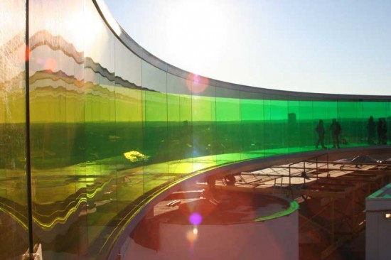
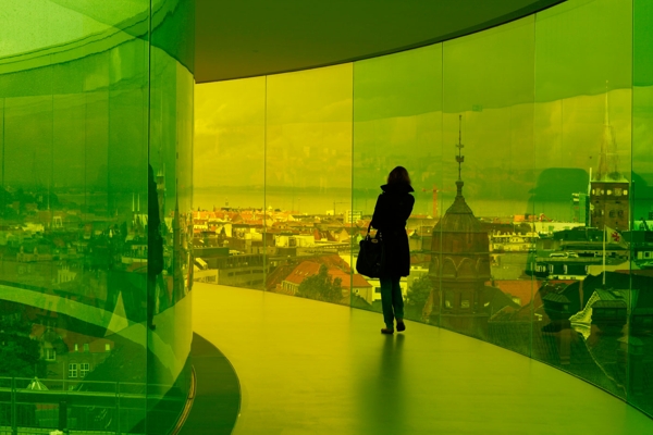
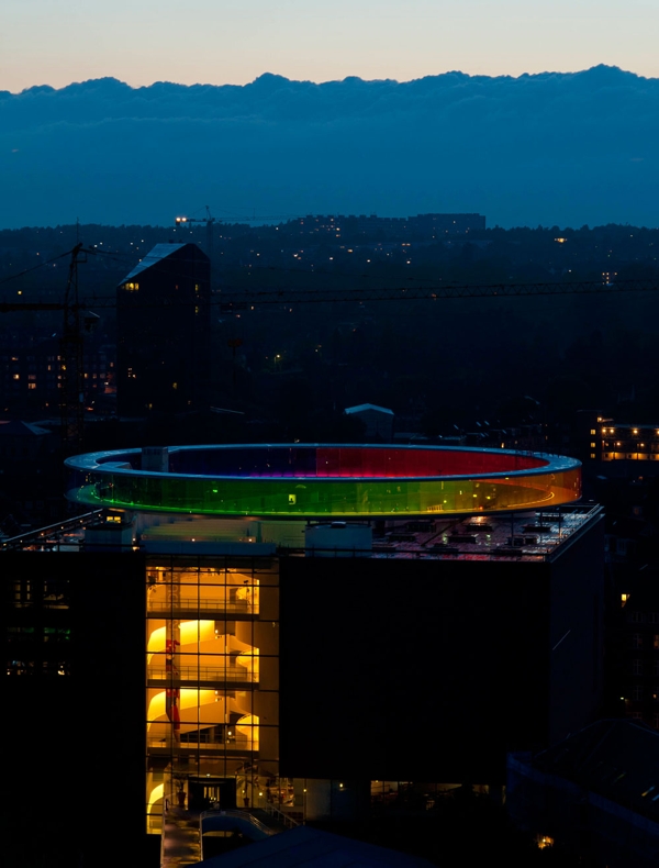
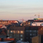
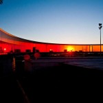
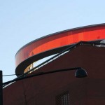
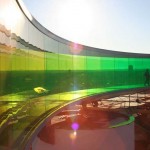
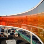
Olafur Eliasson a réalisé cette installation offrant une vue à 360° sur la ville danoise d’Århus. Cette oeuvre circulaire use des couleurs de l’arc-en-ciel pour donner une ambiance originale, et permet d’accentuer le panorama. Plus de visuels de cette installation dans la suite.
Even if this is rather a riding area and playground for moutain bikers (or such) underneath a highway (see below the glacier image), it can give us additionnal ideas toward a sort of "architecture as landscape" approach. We consider "architecture as landscape" a different type of variable environment: it is not the infrastructure that evolves (robotized and heavy approach), but the light, the weather, the (networked, mediated or computed) conditions, the creolization and spatial interferences.
Similar to a landscape where climate and context evolve and where you "freely" migrate within, depending on the conditions and your activity or needs. A sort of Sanaa's Rolex Learning Center, but diy approach.
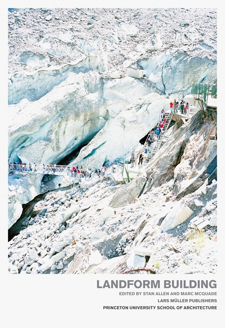
I'm also therefore taking the occasion to mention this new book about a similar topic:
Landform Building, Lars Müller Publishing
Thanks to @BLDGBLOG for the following link, via F.A.D. (Free Association Design)
-----
Circuits Beneath the Freeway
[flow lines of ramps, berms, drops and various home-spun earth retaining systems beneath the I-5 freeway]
While in Seattle this past weekend I had the chance to make a brief stop by the city’s Colonnade Park. Given it’s size, I managed to cover about half of the accentuated terrain (on foot) built into the underbelly of the I-5.
The brilliance of the park’s siting becomes obvious when you are immersed in it: the steep and jumbled topography; the formerly barren and listless ground in the shadow of the overpass; the industrial cathedral that serves as ready-made shelter for the 9-out-of-12 soggy months of the Northwest climate; and perhaps the most critical factor – the challenges and indifference towards such spaces – which allowed for it to be co-opted into something else equally unique and unpolished.
[storage shed built into a ramp and elevated planks]
It hard not to be enamored by the successful and improvised gestalt of the whole thing, in both program and materials. Much of what it is made of was donated or recycled from demolition projects around the city. And typical off-the-shelf items, like permeable waffle pavers (above), have been retooled as robust and removable cellular confinement systems. All the pieces of the circuits have this hand-made, custom quality that is site + multiple user specific.
One comes away with the impression that the park will keep remaking itself incrementally, over and over again. Pieces and segments will be modified as they wear out, with new experiments being plugged in as desired. It seems that the builders and volunteers that have constructed it might actually be a little forlorn if the park were ever fully finished.
Park soon young, Lee chang hee, Lee ki joon
South Korea
The idea behind this skyscraper proposal is to harvest the energy within clouds in regions where more than 200 days per year are cloudy and rainy such as Scotland, North western United States, and South American rain forests.
According to studies, a single lightning produces comparable energy to 100,000 household bulbs for an hour. It is estimated that the world’s population currently needs 14 trillion of kilowatts per year but almost 33% of the electricity is lost during its distribution.
The Cloud and Electricity Generator Skyscraper seeks to tackle these problems by collecting the cloud’s electricity at heights that surpass more than 1 kilometer. The skyscraper is designed with a series of super-tall antennas that collect lightning and stores the energy in a series of battery-like structures distributed along the entire building.
A series of these skyscrapers could provide enough clean energy to a medium-size city. There will be very little energy lost in its distribution as the skyscraper will be located within the cities.
I’ve discovered this new electronic technique that creates new speech out of stuff that’s already there.
Brian Eno
Iceland is volcanically and geologically active. The interior mainly consists of a plateau characterised by sand fields, mountains and glaciers, while many glacial rivers flow to the sea through the lowlands. In this context, Eyjafjallajökull is one of the Iceland’s smaller ice caps located in the far south of the island. It covers the caldera of a volcano 1,666 metres [5,466 ft] in height that has erupted relatively frequently since the last ice age. Eyjafjallajokull most recent eruptions in 2010 were the cause of huge disruption to air travel across western and northern Europe and also caused big impact on farming, harvesting or grazing livestock. We can also read that samples of volcanic ash collected near the eruption showed a silica concentration of 58%—much higher than in the lava flows.
Interesting context for an architecture and landscape course, isn’t it?
Focused on understanding the complex reality of nonbuilt environments beyond poetic contemplation or scientific analysis, The Collector, On Ash Clouds is a course at the Master in Landscape Design Program from Harvard GSD with Paisajes Emergentes as visiting professors, which aims to register, interpret and draw weather and natural phenomenon with the intention of use the generated archive as raw material for the design process of any landscape project.
The course was divided into three major bodies of research*, which was done between a visited site [USA] and a non visited place [Iceland]:
[1] Weather and atmosphere
Natural phenomena are the raw materials used to generate a projected landscape. In this way architecture is not separated from Phenomena, it doesn’t resist them or reject them, it lets them interact. When a given site has no expressive natural phenomena, or none that are appealing to us, we should consider the possibility of de-contextualizing a foreign phenomenon and artificially relocating it.
[2] Emerging Landscapes
Architecture reacts to sites. But we are not interested in poetic, pictorial or nostalgic relationships with locations; instead we look for its emerging qualities to make visible what lies somehow unseen to the public. Our projects want to become systems by which what is concealed becomes manifested. Those manifestations may end up being violent, wild, slow, or may not happen at all. We acknowledge architecture’s limitations in predicting the behavior of nature over time and we accept the risk involved, and make it part of the project.
[3] Drawings and photography
As we conceive them, pictures aren’t just means to represent projects; actually they are design tools at early stages. They permit intuitive speculation on the sceneries the project might face. Sometimes they are precise sketches, others raw collages pointing at interesting aspects. Photography has been a core element to our work, as it lets us document places that we later decontextualize to be used as raw material for design. You could say some projects are just like those images we produced while traveling: collages of things one has seen or wants to see. In addition, photography has allowed us to bridge limitations of architecture’s typical products since weather, deterioration or atmosphere may be otherwise difficult to draw.
The course lasted one week [in January 2011] during some of the most intense days of Boston’s winter. Within that week, the students did a quick exercise of research and then proposed an observatory project, working with unpredictable and violent natural phenomenon as the core of the research. As the instructors Luis Callejas and Sebastian Mejía [from Paisajes Emergentes] pointed: “It can be difficult to determine the boundaries of a complex natural system. The decision is ultimately made by the observer.”
We chose Iceland because it is a very special place… I was there a year ago. The island acts as an observatory. As an island, its environmental conditions are defined by its geological position and all the natural phenomena seems to be amplified. As if geologic time somehow goes faster than human activity in a place with about 300,000 inhabitants.
Working with the ash cloud generated by 2010 eruptions of Eyjafjallajökull volcano, the group studied the conditions and effects that emerged due to this event, and its relation with issues like air navigation, the phenomenon of turbulence, and the possible effects on the island’s ecosystem, among others.
Eyjafjallajökull volcanic ash composite. Source: wiki
The idea of analyzing and working with issues like storms and islands also reminds us the Glacier/Island/Storm studio at Columbia GSAPP by Geoff Manaugh. As Rob Holmes pointed on mammoth:
A possibility: glaciers, islands, and storms are as much events as they are objects; as events, they are primarily composed of processes of accretion and erosion. A storm is a relatively brief event, a glacier is a very long event, and an island is an even longer event [emphasize ours]; yet all are, on a geological time scale, ephemeral.
From statements as “Building is not always edifying: designing with what is already there“, the students have worked on the perspective of investigative landscape design and its important role in history, architecture and imaginative creation. The result is a powerful intensification of emerging landscape conditions as possible solutions to design problems. If Brian Eno once said “For the world to be interesting, you have to be manipulating it all the time.”, now we’re going to visualize geologic time by looking into the past as a way to look into the future, through the student’s eyes and their proposals to “manipulate the world”.
And such as a long event as an island is, we’re going to analyze and write here a series of five post [this, the first one] to talk, using the student’s projects as study cases, about all the possibilities that are contained in the research of this kind of natural phenomena and how they can affect our architectural thinking and our response to environmental crises.
……………………………………………………………
* Text of the three main corps of the studio taken from the course presentation.
- All images, except those specified, by Luis Callejas. Taken on Iceland in August 2010
Harvard GSD Course. Master in Landscape Architecture
Visiting professors: Paisajes Emergentes. January 2011
Students:
Alexander Arroyo, Siobhan Aitchison, Erik Andersen, Kunkook Bae, Senta Burton, Sherry Chen, Rachel Cleveland, Tracie Curry, Heather Dunbar, Lauren Elachi, Michael Easler, Katie Hotchkiss, David Knugi, Kara Lam, Jack McGrath, Connie Migliazzo, Emely Milliman, Madeleine Murphy, Chris Myers, Eunsae Park, Andrew Leonard, Michael Luegering, Lindsey Nelson, Mia Scharphie, Erika Schwarz, Kate Smaby, Heather Sullivan, Xiaowei Wang, Yuyu Wang, Anne Weber, Yizhou Xu, Xin You, Jeongmin Yu, Chuhan Zhang
Instructors: Luis Callejas, Sebastián Mejía, Lukas Pauer
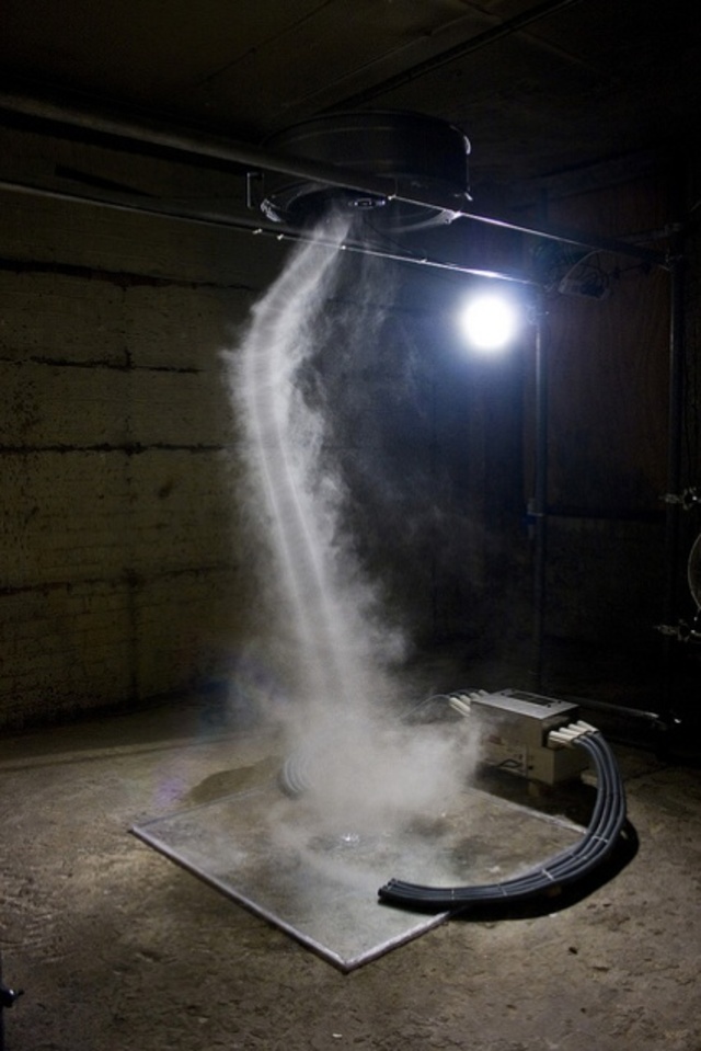
Artist Dennis Oppenheim's "Whirlpool" project, from the summer of 1973, sought to create an artificial tornado on the bed of a dry desert lake in Southern California. It was intended as a "3/4 mile by 4 mile schemata of tornado," the above image explains, "traced in [the] sky using standard white smoke discharge from aircraft."
Employing one of [Oppenheim's] characteristic quasi-scientific methods, the piece was created by issuing radio instructions to an aircraft which discharged a liquid nitrogen vapor trail. The aircraft began by flying in revolutions measuring three quarters of a mile in diameter. Subsequently the pilot was instructed to repeat this manoeuver but, with each revolution, he was made to reduce the size of the diameter of the circle and lose height—and it is no mean feat controlling a plane according to these specifications. The operation had to be repeated three times before the desired whirlpool effect was achieved.
In a short story called "The Cloud-Sculptors of Coral D," J.G. Ballard envisions a tropical atoll where the residents have learned to "sculpt" clouds in the sky, listening to Wagner over loud speakers and using specially engineered gliders and flying techniques.
"Lifted on the shoulders of the air above the crown of Coral D," Ballard writes, "we would carve seahorses and unicorns, the portraits of presidents and film stars, lizards and exotic birds. As the crowd watched from their cars, a cool rain would fall on to the dusty roofs, weeping from the sculptured clouds as they sailed across the desert floor towards the sun."
They are part aesthetic object, part weather system.
[Image: "Column" by Anthony McCall, courtesy of Creative Review].
Both of these came to mind this weekend when I read that artist Anthony McCall is planning to create something called "Column" in Liverpool, to coincide with the London 2012 Olympics. It will be "a spinning column of cloud a mile high," as Creative Review describes it, "visible across the North West region throughout the Olympic year."
Made of cloud and mist, this "swirling micro-climate" will be "created by gently rotating the water on the surface of the Mersey and then adding heat which will make it lift into the air like a water spout or dust devil."
We'll have to see how it actually works out, of course, but the idea that cities might soon deploy large-scale specialty weather-effects—that is, permanent climatological megastructures—instead of, say, Taj Mahals or Guggenheim Bilbaos as a way of differentiating themselves from their urban competition is a compelling one.
The future weather-architects of 2050 A.D. In-house climatologists spinning noctilucent clouds above Manhattan.
Personal comment:
Some comments and additionnal references by Geoff Manaugh about McCall's "Column" project.
This blog is the survey website of fabric | ch - studio for architecture, interaction and research.
We curate and reblog articles, researches, writings, exhibitions and projects that we notice and find interesting during our everyday practice and readings.
Most articles concern the intertwined fields of architecture, territory, art, interaction design, thinking and science. From time to time, we also publish documentation about our own work and research, immersed among these related resources and inspirations.
This website is used by fabric | ch as archive, references and resources. It is shared with all those interested in the same topics as we are, in the hope that they will also find valuable references and content in it.


 One comes away with the impression that the park will keep remaking itself incrementally, over and over again. Pieces and segments will be modified as they wear out, with new experiments being plugged in as desired. It seems that the builders and volunteers that have


 [Image: "
 [Image: "Column" by Anthony McCall, courtesy of