Tuesday, February 15. 2011
Translated By
At the Architectural Association, 11 writers and 11 literary places are the subject of an immaterial translation – via the voice
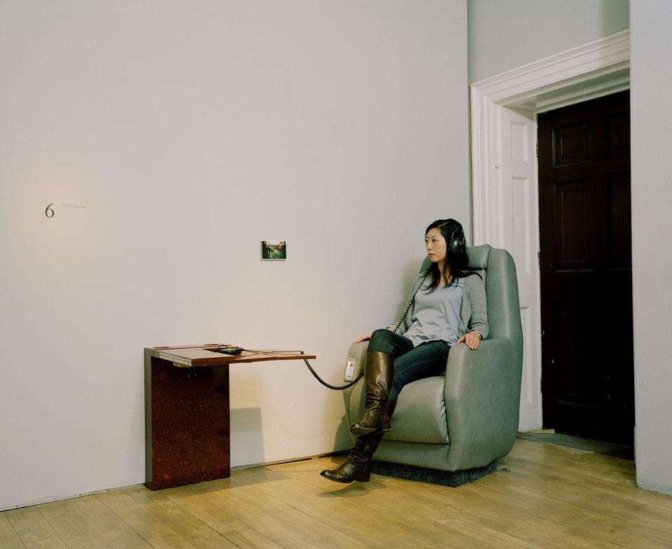
The walls of latest exhibition at London's Architectural Association gallery are painted a muted grey. There are 11 large-ish white numbers placed carefully around the room and small postcards next to the numbers. There seem to be various kinds of chairs or seats everywhere. But, as someone hands over the props of the standard exhibition audio tour, a heavy-duty pair of headphones and what looks like an audio guide, it becomes clear that the exhibition doesn't take place in this room. It is not a visual experience at all.
The show is a kind of audio mix-tape of fictional and real places written by eleven international authors, including Douglas Coupland, Rana Dasgupta, Hu Fang, Julien Gracq, Tom McCarthy, Guy Mannes Abbott, Sophia Al Maria, Hisham Matar and Neal Stephenson. These vivid short stories or extracts are spoken by actors and last around ten minutes, variously traversing landscapes from Ramallah to turn-of-the-century Sofia, a cold, dead Vancouver to a dusty checkpoint in Palestine. Each of the authors sent a small picture postcard – a trigger image – which holds the listeners' attention.
The exhibition doesn't happen in the room or on the seats – it takes place between the spongy cushion of the headphone and the visitor's ear. Next to the bar at London's Architectural Association, the show's curators Shumon Basar and Charles Arsène Henry discuss the concepts and processes that went into making a show, without a show.
(...)
More about it HERE.
Related Links:
Friday, October 02. 2009
Phantom City
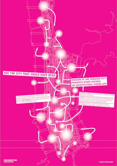 [Image: Museum of the Phantom City by Cheng+Snyder for the Van Alen Institute].
A fantastic new iPhone app by Irene Cheng and Brett Snyder has come to market in New York City this autumn. Sponsored by the Van Alen Institute, Museum of the Phantom City is "a public art project that allows individuals to browse visionary designs for the City of New York on their iPhones."
- Users can view images and descriptions of speculative projects ranging from Buckminster Fuller’s dome over midtown Manhattan, to Antonio Gaudi’s unbuilt cathedral, to Archigram’s pop-futurist “Walking City,” all while standing on the projects’ intended sites.
In other words, you go around the city, iPhone in hand – a kind of architectural dowsing rod held in front of you – discovering the traces of buildings that never were (perhaps even fragments of a city yet to come).
Proposals by Buckminster Fuller are suddenly as real as the Empire State Building – after all, they're both pictured right there on your iPhone...
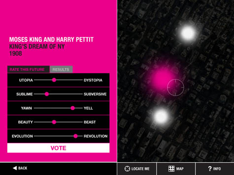 [Images: Screen shots from Phantom City by Cheng+Snyder].
As the New York Times wrote this morning:
- A mile-high dome shades Midtown Manhattan, an airport floats off Battery Park, Harlem is enveloped in a hulking megastructure literally lifting residents out of poverty, and the tallest building in the world, continuously under construction, sprouts from ground zero, growing without end.
“It’s the city that never was but could have been,” said Irene Cheng, an architectural historian. “Sort of an alternate future.”
Without mining the architectural avant-garde and its history of impossible projects, and before you even get to things like science fiction films and comic books, and as you hold yourself back from exploring the spatial reserves of ancient myth and urban legend – weird tunnels beneath midtown, World War II bunkers, secret apartments of the rich and famous – you can simply tap the ongoing economic recession for architectural content.
It would be easy enough, in fact, to put together a tour of building projects that never made it past the recession – New York's so-called "Lost Skyline" – or, for that matter, of the buildings that never made it past the Depression.
You walk past a certain corner on the Upper West Side and your iPhone starts to ring: you're being called by a missing building... Absent structures detected in a wireless blur, leaving messages for you (complete with call-back number).
Electromagnetic voice phenomena in architectural form.
 [Image: Screen shot from Phantom City, featuring Superstudio's Continuous Monument].
On one level, of course, it's worth asking whether or not it's a problem that all of these new and exciting visions for 21st-century urban life are only accessible to people rich enough to afford iPhones – but, on another level, why not use the tools that exist, no matter how expensive they might be, in order to try out new models for historical and spatial exploration?
Caving, for instance, requires caving equipment – and not everyone can afford to stock up. But that's no reason to stop exploring the underworld.
At a conference in Turin earlier this summer, I was on a panel with Bruce Sterling and Nicolas Nova, where Nova asked this exact question. Having just shown us all a series of slides in which new ways of interacting with, and learning about, the city had been suggested, he pointed out that most of these things required an iPhone. But do we really want to build and promote the city of tomorrow, if it's effectively inaccessible to a particular class of consumers?
Yet, one could argue, this is exactly what we've done with cars; the spatial needs of the automobile industry have shaped our cities far more than the cultural and economic – and possibly even neurological – needs of those cities' inhabitants.
So will iPhones do to urban information what cars have done to the streetscape?
 [Image: The iPhone at work, detecting the Phantom City].
In any case, back in 2008, in a post that now seems remarkably dated, I suggested that Google Maps should come with a "sci-fi layer" – that is, a layer that would document where in your city certain events had taken place or certain structures had stood in a work of fiction. For instance, the building that Robert Neville's dog runs into in I Am Legend or the trainyard from Escape From New York, the apartments from Make Room! Make Room!, the high-rise penthouse from The Day After Tomorrow...
Those are Manhattan-centric examples, of course, and drawn only from science fiction, but this could easily be expanded to include landscapes and structures elsewhere, from the deserts of the Empty Quarter to central Paris, and it could include other genres, from the poems of John Ashbery to Howl to The Great Gatsby.
You could even have a "mythology layer" – roaming around Scandinavia, tracking Thor or digging for the roots of Yggdrasil – or a "theology layer": you go to Israel and your iPhone short-circuits from the laminations of charged geography around it. Pillars of salt, sacred basements, dead walls and abandoned forts.
In fact, I'm further reminded of a project produced this past summer by Sally Hsu, one of my students at Urban Islands down in Sydney. Hsu came up with something she called the Research Institute of Phantomology, a fake historical research society whose specially-invented machines could detect missing buildings: structures that had been demolished and lost to history. You could use these throughout the Sydney Harbor – or specifically on Cockatoo Island, where our studio was set – in order to trace the architectural remains of history.
One of those devices, according to Hsu, was the Architectural Ghost Chaser: it would lead historians directly to the ruins of old buildings in the earth.
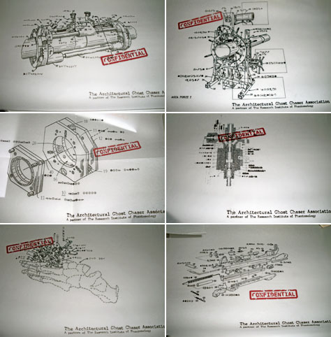 [Image: Patent diagrams for an "Architectural Ghost Chaser" by Sally Hsu; Urban Islands 2009].
A tongue-in-cheek proposal, of course – Hsu even made patent diagrams to illustrate it, as well as a fake cover for New Scientist featuring the remarkable device – it nonetheless kicked-off an interesting conversation about demolished buildings, urban archaeology, and the strategies through which we could detect the ruins of the past if physical excavation is not an option. After all, we've already got things like ground-penetrating radar – through which we can map and explore an ancient Roman city beneath Wroxeter, England, without digging a single hole – and we've even got muon detectors. But imagine discovering new archaeological sites through an iPhone app!
So why not build a tricked-out PKE Meter attuned to architectural space? At the exact intersection of Sally Hsu's Institute of Phantomology and the iPhone?
In other words, why not create something like the Museum of the Phantom City?
Cheng+Snyder's free download opens up a new kind of historical spectating: architectural tourism of the unbuilt. Perhaps someday we'll be done with monographs, traveling exhibitions, and even senior thesis reviews; we'll simply upload all our projects into the Phantom City and let the world decide their worth. Crowds of tourists mill about on 13th Street, looking around at the imaginary buttresses of a superstructure you've spent three years digitally assembling.
Download the app via the iTunes store and see for yourself.
Monday, April 06. 2009
The Future of Mobile Social Networking
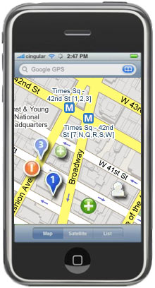 |
| Places to go: In June, the startup Pelago is expected to release a version of Whrrl, its mobile social-mapping software, for the iPhone. Whrrl helps people locate friends or find things to do nearby, and it incorporates recommendations made by others in the user’s social network. The image above is an artist's interpretation of what Whrrl might look like on an iPhone. Credit: Technology Review |
One rising company that's hoping for a mention during the Steve Jobs Show is Pelago, a startup that recently garnered $15 million from funders, including Kleiner Perkins Caufield and Byers. Pelago will soon offer a version of its software, called Whrrl, for the iPhone. The software enables something Pelago's chief technology officer, Darren Erik Vengroff, calls social discovery: using the iPhone's map and self-location features, as well as information about the prior activities of the user's friends, Whrrl proposes new places to explore or activities to try.
"If you think about your day-to-day life and how you discover things around you and places to go, to a great extent the source of that information is your friends," Vengroff says. With Whrrl, a user can "look through the eyes of friends and see the places they find compelling." The software begins with the user's position on the iPhone's map and indicates a smattering of nearby establishments. If the user's friends have visited and rated these places, the software indicates that as well. The map also shows the positions of nearby friends who have enabled a feature that lets them be seen by others.
Whrrl may turn out to be the leading edge of a wave of new location-based applications. "I think we're going to see a lot of new players showing up in this space," says Kurt Partridge, a research scientist at the Palo Alto Research Center who works on a similar project called Magitti. "Part of the reason," he says, "is the universal availability of GPS or access to location, which hasn't been available to application writers before." The iPhone and Nokia's N95 phone are two examples of phones that provide location data to computer programmers. Google's forthcoming Android mobile operating system may also help push location-based applications onto the market.
The idea of community-generated reviews is, of course, not new. The popular recommendation service Yelp, for example, is already integrated into Google Maps. And the concept of locating friends using a mobile phone has also been around for years; Loopt, a service that runs on Sprint and Boost Mobile phones, is one of the most common examples. Whrrl, which can also be downloaded onto BlackBerry Pearl, Curve, and Nokia N95 smart phones, is commonly compared to both types of service. But it differs from either in that it combines aspects of both. In addition, Vengroff explains, Whrrl has collected details on establishments in 17 cities, which allows the service to provide fine-tuned local search, letting the user narrow down the hunt for, say, a café to one that has outdoor seating and vegetarian options and is recommended by at least one friend.
While the possibilities presented by Whrrl are exciting to many, its mass appeal has yet to be established. First, the location data might not be fine-grained enough to be useful in all cases, so it could lead to false positives. The iPhone relies on data from Skyhook Wireless, a company that uses an enormous database of the locations of Wi-Fi base stations to locate a person within about 30 meters; GPS, however, could do much better. Also, Whrrl is most useful when members of the user's social network actively contribute reviews. This requires that the user's friends have smart phones--and the motivation to critique the places they go.
Still, the biggest obstacle faced by services like Whrrl is privacy concerns. Vengroff points out that users control whom the program lists as their friends, who can read their reviews, and who can see their physical locations. The software also offers a "cloaking" feature that lets a person become completely invisible to his or her entire Whrrl network.
"Generally, if you give people more control, they're more willing to participate," says Tanzeem Choudhury, a professor of computer science at Dartmouth College. However, some people are still concerned about how long the company will store information about its customers' locations. Choudhury says that these first-generation services will likely be used by small groups of early adopters who are more aware than most of potential privacy risks and will push companies to confront them.
Regardless, Choudhury and others are excited about the potential of services such as Whrrl. In the future, she suspects, location-based services will include more predictive features. For instance, instead of explicitly requiring you to write a review, the software might recognize how often you visit a restaurant and infer that it is a favorite. "Eventually, I think that a whole lot of exciting technology will emerge that figures out how to reduce the burden on the user," Choudhury says. "There will always be the case where user input will be important, but when we find the sweet spot, that's when I think it will take off."
Copyright Technology Review 2008.
-----
Related Links:
Personal comment:
The article up there si dated from June 2008, but Whrrl is still in beta 2.0. Since then, we've seen of course this type of services grow and this will obviously continue. It's interesting to read the article with already some distance. What seems in june 2008 something to come is now so obvious (and that was in fact already quite obvious).
Friday, February 06. 2009
Datascape: narrating hybrid virtual/physical worlds
Monday, December 01. 2008
Media Lab creates Center for Future Storytelling [MIT News Office]
Wednesday, September 24. 2008
Geo-Biography in Google Earth (McCain, sorry...)
En essayant de faire abstraction du fait qu'il s'agisse de John McCain (mais on attend avec impatience la chasse à l'ours de S. Pahlin dans GE ;)), une biographie mise en géographie dans Google Earth et l'occasion de visiter toutes les bases aérienne américaines ...
---
September 23, 2008
 The folks at BrightGIS have created a geo-biography of Sen. John McCain's early life and military service which you can view in Google Earth. You simply download their McCain KML file
 ![]() , and follow the instructions you'll see inside GE. I like they way they have used placemarks to view the content and navigate between the different locations of McCain's life. There are other techniques for navigating content, but this one works pretty well I think. The file is designed as a political promotion, but is informative and useful and the links for "getting involved" and contributing are not too obtrusive. BrightGIS offers services to build Google Earth/Maps content. You can also view their McCain file in Google Maps, but the GE version is more entertaining.
, and follow the instructions you'll see inside GE. I like they way they have used placemarks to view the content and navigate between the different locations of McCain's life. There are other techniques for navigating content, but this one works pretty well I think. The file is designed as a political promotion, but is informative and useful and the links for "getting involved" and contributing are not too obtrusive. BrightGIS offers services to build Google Earth/Maps content. You can also view their McCain file in Google Maps, but the GE version is more entertaining.
fabric | rblg
This blog is the survey website of fabric | ch - studio for architecture, interaction and research.
We curate and reblog articles, researches, writings, exhibitions and projects that we notice and find interesting during our everyday practice and readings.
Most articles concern the intertwined fields of architecture, territory, art, interaction design, thinking and science. From time to time, we also publish documentation about our own work and research, immersed among these related resources and inspirations.
This website is used by fabric | ch as archive, references and resources. It is shared with all those interested in the same topics as we are, in the hope that they will also find valuable references and content in it.
Quicksearch
Categories
Calendar
|
|
July '25 | |||||
| Mon | Tue | Wed | Thu | Fri | Sat | Sun |
| 1 | 2 | 3 | 4 | 5 | 6 | |
| 7 | 8 | 9 | 10 | 11 | 12 | 13 |
| 14 | 15 | 16 | 17 | 18 | 19 | 20 |
| 21 | 22 | 23 | 24 | 25 | 26 | 27 |
| 28 | 29 | 30 | 31 | |||
