Wednesday, October 15. 2008
More Street View Imagery for France in Google Earth/Maps
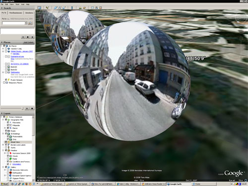
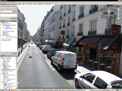
 As reported at Google Maps Mania, Google has released new Street View imagery in France. Google had already released Street View imagery in July for the Tour de France. Now they have more complete coverage for the following cities: Paris, Toulouse, Lyon, Marseille, Nice, and Lille. Most people are aware you can view the Street View imagery in Google Maps, but you can also see these new spherical panoramic photos inside Google Earth with a 3D interface.
To see the images in Google Earth, turn on the Street View layer and zoom in a bit to see the camera icons over France. You can fly to a city covered with the Street View icons to find an interesting site. Then click on a camera icon near your desired location. Click "Show Full Screen" or double click the icon to enter the Photo Viewer mode. This mode lets you look in all directions using the mouse or keyboard arrows. You can also zoom in and out with the mousewheel. See a video demonstration of the Google Earth Street View imagery.
-
Personal comment:
Je n'avais pour ma part pas encore vu "street view" dans Google Earth et ça reste quand même assez impressionnant tout ce travail de mapping. Assez "Sysiphien"! - En s'approchant des icones d'images, vous verrez les "boules" de type Quicktime VR apparaître (la rue Daguerre et Plan B- Paris, dans l'image du bas). Double "click" sur la boule et vous entrez dans l'image puis possibilité de naviguer d'image en image (une images tous les 10m environ...). -- La vue de GE avec les boules fait d'ailleurs un peu penser à des vues dans l'env. digital de Brillantmont où il y avait ces sortes de "carrés" d'immersion dans le campus de BM.
Monday, October 13. 2008
Newly Discovered Buried Peruvian Pyramid Visible in Google Earth
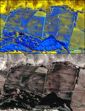 Researchers recently discovered a buried pyramid in the Peruvian desert using satellite imagery and "special algorithms". The buried pyramid is about a mile from the Cahuachi's archeological site. But, if you use the satellite photo released by the researchers you can find the location in Google Earth. You can easily see evidence of the site yourself in GE's imagery. It turns out the structure is underneath a crop field - and the underlying structure has changed the color of the soil such that shapes are visible in the DigitalGlobe satellite photo. GEB reader Markus Mehring told me about this discovery and after seeing the satellite image shown in news reports, he matched the location in Google Earth. See it yourself here
 ![]() . Markus thinks the data the researchers used was possibly the same DigitalGlobe image used in Google Earth (he says it matches very closely). According to the researchers, this is a large pyramid with a base of 300 feet on each side and with seven levels similar to another pyramid they are already excavating.
. Markus thinks the data the researchers used was possibly the same DigitalGlobe image used in Google Earth (he says it matches very closely). According to the researchers, this is a large pyramid with a base of 300 feet on each side and with seven levels similar to another pyramid they are already excavating.
By the way, the Cahuachi site is just south of the famous Nazca Lines. And, here is a good Google Earth Community post showing a tour of the Nazca lines in Google Earth (with image overlays).
Google Earth imagery is definitely good enough to discover archeological sites - if you have a eye trained to look at the imagery properly. In fact, there have been a number of discoveries made with Google Earth. A long-time friend of mine, by the name of Scott Madry is a professor at the University of North Carolina, and has used Google Earth to discover dozens of sites in France thanks to Google Earth. But, Scott has been using aerial imagery for archeology for decades. Read a National Geographic story about Scott's Google Earth work. About.com has written a nice article about using Google Earth for archeology as well. And, if you're really fascinated about seeing archeological sites in Google Earth, make sure to check out JQ Jacobs ancient monuments site which shows all kinds of locations in Google Earth.
Wednesday, October 08. 2008
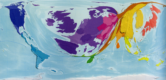
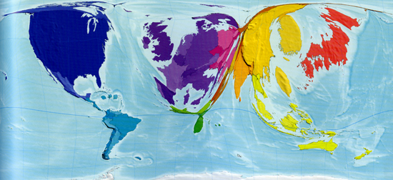
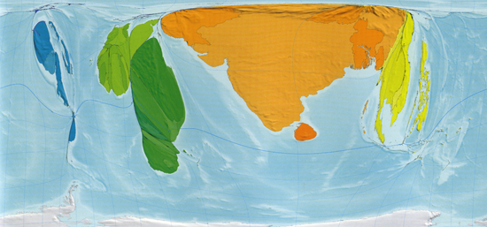
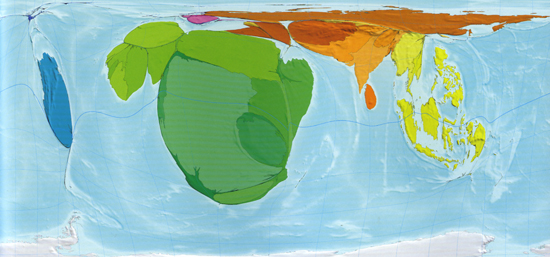
The Atlas of the Real World
All captions taken from The Atlas of the Real World:
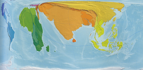
Nuclear Weapons: The size of each territory indicates the number of known or suspected strategic nuclear weapons*
“In 2002 eight territories were known or suspected to have strategic nuclear weapons: the United States, Russia, France, China, the United Kingdom, Israel, India and Pakistan… The United States, which has the largest number of nuclear weapons, has 240 times more than Pakistan, which has the fewest.” *Strategic nuclear weapons, estimated total, 2002.
——————————————
Books Published: The size of each territory shows the number of new book titles published each year*
“Each new book published is counted only once on this map, regardless of how many copies it sells… A book is defined as having at least 50 pages; a pamphlet has 5 to 49 pages. Publications with fewer than 5 pages are not shown on this map. Worldwide, about a million new book titles were published in 1999, with the largest numbers published in the United Kingdom, China and Germany. Overall, the map is dominated by Western Europe, which is home to a number of well established publishing houses.” *Books titles published, number per million people, 1999.
——————————————

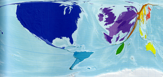
Internet Users in 1990: The size of each territory indicates the number of people using the infant internet in 1990*
“Just 3 million people worldwide had access to the internet [in 1990]: 73% of these were in the United States and 15% in Western Europe, with just a few in other places such as Canada, Australia, Japan, South Korea and Israel and practically no access anywhere else.” *Internet users in 1990, thousands.
——————————————
Internet Users in 2002: The size of each territory indicates the number of internet users in 2002, by which time its reach and sophistication had increased dramatically*
“The number of people using the internet saw a 200-fold increase between 1990 and 2002. By 2002 there were 631 million internet users worldwide. The distribution of users also changed radically… By 2002 there were substantial numbers of internet users also in the Asia-Pacific and Australasia, South Asia, South America, Eastern Europe and China, and small but significant numbers in Northern Africa, East and Southern Africa, and the Middle East and Central Asia.” *Internet users in 2002, users per 1,000 people, 2002.
——————————————
Forest Depletion: The size of each territory indicates the annual rate of depletion of forests, measured in terms of US dollar value at current prices*
“As quantified here, forest depletion is the net rate of loss of forests as a result of tree felling that is not offset by regrowth. The loss is measured in terms of the market value of the trees in the form of untreated round timber. In other words this map shows, at the territory level, the dollar value of wood that is not sustainably harvested… Almost half of the world total (46%) occurs in India, where the annual timber depletion exceeds that of the next 25 countries combined, althought the population of India is also almost as large as the combined population of those 25 other territories.” *Forest depletion, US$ billion, 2003.
——————————————
War Deaths in 2002: The size of each territory indicates the number of deaths directly attributable to armed conflict in 2002*
“In 2002 there were an estimated 172,000 war deaths worldwide. The majority of territories recorded none; the deaths shown here occurred in only 80 of the 200 territories, and 70% of them occurred in just 9 territories. The Democratic Replublic of Congo bore the largest share of war deaths in 2002, at 26%. As a fraction of total population Burundi was hardest hit, with 1.2 people in every 1,000 dying.” *War deaths 2002, thousands of people killed in wars.
——————————————
Abject Poverty - People Living on US$2 a Day: The size of each territory shows the number of people living on US$2 a day or less, adjusted for local purchasing power: barely enough to survive, let alone thrive*
“In 2002, 43% of the world’s population lived in US$2 a day or less… Where almost the entire population of a territory lives on incomes at this level, it is unsurprising if undernourishment is high, the level of education is low and life expectancy short. In both Nigeria and Mali, 9 out of every 10 people subsist on less than US$2 a day.” *Living on US$2 a day or less, millions of people.
——————————————
Number of People Living on More Than US$200 a Day: The size of each territory indicates the number of living on more than US$200 a day, adjusted for local purchasing power. Over half of these high earners live in the United States*
“A majority (61%) of the Japanese population live in households with daily incomes between US$50 and US$100, adjusted for purchasing power parity. North American and Western Europe are also particularly large on this map, while South Asia and Central Africa have almost completely disappeared.” *Living on over US$200 a day, % of population.
——————————————
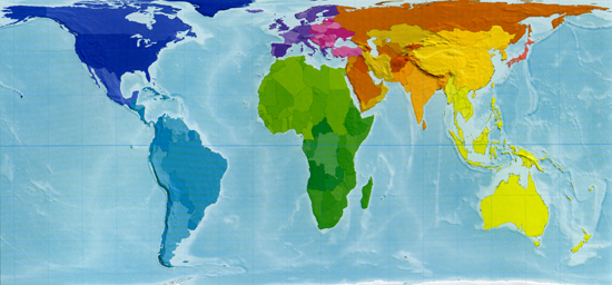
Land Area: The size of each territory represents exactly its land area in proportion to that of the others, giving a strikingly different perspective from the Mercator projection most commonly used
All images reproduced with permission.

The Atlas of the Real World is published next week from Thames & Hudson, (£29.95)
Related Links:
Tuesday, October 07. 2008
Geography, Urbanity & Democracy
By Geoff Manaugh
-
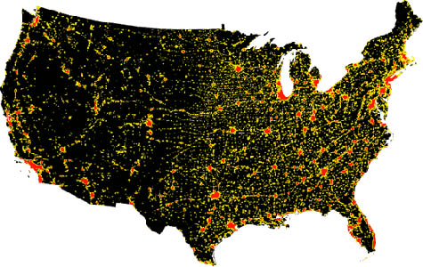
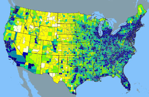 [Image: The population density of the United States, ca. 2000, via Wikipedia].
If you'll excuse a quick bit of landscape-inspired political speculation, I was reminded this morning of something I read last year on Boing Boing and which has stuck with me ever since – and that's that there are more World of Warcraft players in the United States today than there are farmers.
Farmers, however, as Boing Boing and the original blog post it links to are both quick to point out, are often portrayed in media polls as a voice of cultural and political authenticity in the United States. They are real Americans, the idea goes, a kind of quiet majority in the background that presidential candidates and media pundits would be foolish to overlook.
If you want a real cross-section of Americana, then, you're supposed to interview farmers and even hockey moms – but why not World of Warcraft players? This is just a rhetorical question – it would be absurd to suggest that World of Warcraft players (or architecture bloggers) somehow have a special insight on national governance – but, as cultural demographics go, it's worth asking why politicians and the media continue to over-prioritize the rural and small-town experience.
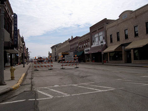 [Image: A street in Columbus, Wisconsin, the small and, at the time, semi-rural town in which I grew up, photographed under a Creative Commons license by Royal Broil].
In a related vein, it's often said in the U.S. that certain politicians simply "don't understand the West": they're so caught up in their big city, coastal ways that they just don't get – they can't even comprehend – how a rancher might react to something like increased federal control over water rights or how a small-town mayor might object to interfering rulings by the Supreme Court. Politicians who don't understand the west – who don't understand the rugged individuality of ranch life or the no-excuses self-responsibility of American small towns – are thus unfit to lead this society.
But surely the more accurate lesson to be drawn from such a statement is exactly the opposite?
One could even speculate here that politicians from small towns, and from the big rural states of the west, have no idea how cities – which now house the overwhelming majority of the American population – actually operate, on infrastructural, economic, socio-political, and even public health levels, and so they would be alarmingly out of place in the national government of an urbanized country like the United States.
If the United States – if the entire world – is rapidly urbanizing, then it would seem like literally the last thing we need in the White House, in an era of collapsing bridges and levees, is someone whose idea of public infrastructure is a dirt road.
Put another way, perhaps coming from a ranch or a small town is precisely why a certain candidate might be unable to govern a nation that is now 80% urban.
It's a political collision of landscape management strategies.
 [Image: Urban areas in the U.S. Map courtesy of NASA].
On the other hand, perhaps this juxtaposition would be exactly why a rural or small-town candidate could be perfect for the job – fresh perspectives, thinking outside the box, and so on. After all, a good rancher is surely a better leader than a failed mayor.
Or, to take an even more aggressive stand against this argument, surely the administrative specifics of your previous professional life – you were a doctor, a minister, a novelist, a governor, a business owner, a soccer dad – are less important than your maturity, knowledge, clarity of thought, and judgment?
Even having said that, though, I can't help but wonder if a candidate might "understand" one particular type of settled landscape – a small town, a thinly populated prairie, an icy state with a population one-fifth that of Chicago – but not another, more heavily urbanized type of landscape (i.e. the United States as a whole).
So I was reminded again of the opening statistic from Boing Boing – a statistic that I have not researched independently, mind you, but that appears to be based on this data – when I read that President Bush had stopped off this morning to speak about the credit crisis "with consumers and business people at Olmos Pharmacy, an old-fashioned soda shop and lunch counter" in San Antonio, Texas.
The idea here – the spatial implication – is that Bush has somehow stopped off in a landscape of down-home American democracy. This is everyday life, we're meant to believe – a geographic stand-in for the true heart and center of the United States.
But it increasingly feels to me that presidential politics now deliberately take place in a landscape that the modern world has left behind. It's a landscape of nostalgia, the golden age in landscape form: Joe Biden visits Pam's Pancakes outside Pittsburgh, Bush visits a soda shop, Sarah Palin watches ice hockey in a town that doesn't have cell phone coverage, Obama goes to a tractor pull.
It's as if presidential campaigns and their pursuing tagcloud of media pundits are actually a kind of landscape detection society – a rival Center for Land Use Interpretation – seeking out obsolete spatial versions of the United States, outdated geographies most of us no longer live within or encounter.
They find small towns that, by definition, are under-populated and thus unrepresentative of the United States as a whole; they find "old-fashioned" restaurants that seem on the verge of closing for lack of interested customers; they tour "Main Streets" that lost their inhabitants and their businesses long ago.
All along they pretend that these landscapes are politically relevant.
My point here is not that we should just swap landscapes in order to be in touch with the majority of the American population – going to this city instead of to that town, visiting this urban football team instead of that rural hockey league, stopping by this popular Asian restaurant instead of that pie-filled diner (though I would be very interested to explore this hypothesis). I simply want to point out that political campaigning in the United States seems almost deliberately to take place in a landscape that no longer has genuine relevance to the majority of U.S. citizens.
The idea that "an old-fashioned soda shop" might give someone access to the mind of the United States seems so absurd as to be almost impossible to ridicule thoroughly.
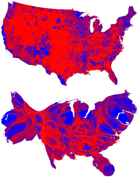 [Images: From the fascinating series of electoral maps produced by M. T. Gastner, C. R. Shalizi, and M. E. J. Newman after the 2004 U.S. presidential election].
Of course, I understand that there are electoral college strategies at work and so on; but what I think remains unchallenged throughout all of this is the idea that small town voters somehow offer a more authentic perspective on the political life of this country – and not, say, people in West Hollywood or the Upper East Side or Atlanta or even Reno. Or World of Warcraft players. Or people who eat sushi. People who read Harry Potter novels.
"President Bush stopped off today with a group of people who read Harry Potter novels – the eleventh-largest demographic group in the United States – to discuss the ongoing financial crisis..."
Which group is larger, more important, more likely to vote, more demographically representative of the United States?
Call them micro-niches or whatever new marketing term you want to invent, but it seems like American politicians are increasingly trapped in a kind of minor landscape, a geography that is demonstrably not that within which the majority of Americans currently live.
"Barack Obama campaigned today in the early 1960s by visiting a small pancake house near Springdale..."
In any case, the entire political premise of the last eight years seems to have been one of landscape: big city dwellers near the Great Lakes and the ocean coasts simply don't understand small town communities, and they're embarrassingly out of touch with the everyday big skies of lonely ranchers on the plains. But while this might be true – and I don't think it is, frankly – reversing this belief is surely even more alarming: the idea that someone whose background includes ranches and small towns should go on to lead an urban nation in an urban world seems questionable at best – and potentially dangerous in actual practice.
Again, though, there seems to be no adequate way to measure how political exposure to certain settled landscapes might affect a candidate's ability to govern – and so this post should simply be taken as a kind of geographic speculation about democracy in the United States.
But it does raise at least one interesting group of questions, I think, including: what are the real everyday landscapes of American life, if those landscapes no longer include old-fashioned soda shops and small-town hockey arenas – or do such everyday landscapes simply no longer exist?
And if there are no everyday landscapes, then surely every landscape we encounter is, by definition, extraordinary – so we should perhaps all be paying more attention to the spatial and architectural circumstances of our daily lives?
Further, if political candidates have managed to discover – and to campaign almost exclusively within – an American landscape that seems not yet to have been touched by the trends and technologies of the twenty-first century, then why is that – and is it really a good indication that those candidates will know how to govern an urbanized, twenty-first century nation?
Finally, if urban candidates – or coastal candidates, whatever you want to call them – "don't understand the west," which is simply cultural code for not understanding small town life and for being out of touch with the moral hardships of the American countryside, then surely that's not altogether bad in a country that is 80% urbanized?
Put another way, it would certainly be frustrating to think that a candidate doesn't understand how a cattle ranch or an alfalfa farm operates, or that a candidate has no experience with a small town and its parent-teacher associations and so on – but it is extraordinarily troubling to me to think that a candidate doesn't understand how, say, New York City functions – or Chicago, or Los Angeles, Miami, Boston, San Francisco, Denver, Seattle, Atlanta, or Phoenix – let alone the globally active and thoroughly urbanized economic networks within which these and other international cities are enmeshed.
Surely, then, it is small town candidates and politicians with ranching backgrounds who are demonstrably unqualified for the leadership of an urban country?
Surely we need urban candidates for the twenty-first century?
Related Links:
fabric | rblg
This blog is the survey website of fabric | ch - studio for architecture, interaction and research.
We curate and reblog articles, researches, writings, exhibitions and projects that we notice and find interesting during our everyday practice and readings.
Most articles concern the intertwined fields of architecture, territory, art, interaction design, thinking and science. From time to time, we also publish documentation about our own work and research, immersed among these related resources and inspirations.
This website is used by fabric | ch as archive, references and resources. It is shared with all those interested in the same topics as we are, in the hope that they will also find valuable references and content in it.
