Tuesday, June 30. 2009
Re-engineering the earth
An article in the most recent issue of the Atlantic Monthly explores aggressive “geo-engineering” projects:
“Humans have been aggressively transforming the planet for more than 200 years. The Nobel Prize–winning atmospheric scientist Paul Crutzen—one of the first cheerleaders for investigating the gas-the-planet strategy—recently argued that geologists should refer to the past two centuries as the “anthropocene” period. In that time, humans have reshaped about half of the Earth’s surface. We have dictated what plants grow and where. We’ve pocked and deformed the Earth’s crust with mines and wells, and we’ve commandeered a huge fraction of its freshwater supply for our own purposes. What is new is the idea that we might want to deform the Earth intentionally, as a way to engineer the planet either back into its pre-industrial state, or into some improved third state. Large-scale projects that aim to accomplish this go by the name “geo-engineering,” and they constitute some of the most innovative and dangerous ideas being considered today to combat climate change. Some scientists see geo-engineering as a last-ditch option to prevent us from cooking the planet to death. Others fear that it could have unforeseen—and possibly catastrophic—consequences. What many agree on, however, is that the technology necessary to reshape the climate is so powerful, and so easily implemented, that the world must decide how to govern its use before the wrong nation—or even the wrong individual—starts to change the climate all on its own.”

A permanent fleet of ships sails the globe, churning the ocean with special propellers to spray seawater into the air and make clouds whiter and fluffier. A battery of twenty electromagnetic guns, “each more than a mile long and positioned at high altitudes”, that would fire tens of millions of ceramic frisbees at the gravitational midpoint between the earth and the sun, putting “the Earth in a permanent state of annular eclipse”. Hovering zeppelins spew sulfur dioxide into the air, turning the sky red at sunset. Forests of Freeman Dyson’s genetically engineered trees hungrily suck carbon out of the air. Vented structures, similar to industrial cooling towers, are filled with grids coated in a solution that captures carbon; the captured carbon is then scrubbed off the grids and sequestered deep below ground in exhausted oil wells. Antarctic waters are seeded with iron, producing massive plankton blooms that cool the globe.

Perhaps the most unexpected (and frightening) turn in the Atlantic article is the suggestion of a worst-case scenario in which a “rich madman… obsessed with the environment” or “a single rogue nation” sets one of these plans into motion unilaterally, with potentially disastorous global side-effects — in the case of the sulfur aerosols, for instance, it is quite likely that any interruption of the supply of aerosols would produce immediate and catastrophically rapid climate change. An appropriately sobering possibility to consider, for though the scenarios seem outlandish(ly exciting) and the risks are real, they are being given hearing not just at the fringes of scientific debate, but at bodies like the National Academy of Sciences.
-----
Vis Mammoth
Tuesday, June 23. 2009
Server space

NY Times: Data Center Overload
“Much of the daily material of our lives is now dematerialized and outsourced to a far-flung, unseen network … But where is ‘there,’ and what does it look like? ‘There’ is nowadays likely to be increasingly large, powerful, energy-intensive, always-on and essentially out-of-sight data centers. These centers run enormously scaled software applications with millions of users … Small wonder that this vast, dispersed network of interdependent data systems has lately come to be referred to by an appropriately atmospheric — and vaporous — metaphor: the cloud … [T]he electricity on a low-end server will now exceed the server cost itself in less than four years — which is why the geography of the cloud has migrated to lower-rate areas…”

Photos: NY Times: Search Me
-----
Via Space & Culture
Personal comment:
Rien qu'on ne sache déjà, mais ça le souligne... A mettre en lien avec l'article précédent concernant le chauffage de bâtiment par un cluster de serveurs.
Saturday, June 20. 2009
Layar est-il le futur de la réalité augmentée ?
 La firme Hollandaise SPRXmobile devrait sortir sous peu une application pour Android qu’elle désigne comme “le premier navigateur à réalité augmenté”. Appelé Layar, l’application est une plateforme qui rend accessible des contenus et des données en surimpression de la vue offerte par la caméra vidéo du téléphone. Des commerces, banques, sociétés spécialisés dans la recherche de restaurant et services d’immobiliers ont deja créé des couches d’informations disponibles sur la plateforme, qui pour l’instant se limite à la Hollande. La démonstration est tout simplement bluffante.
Le blog, NotJustReality cite Raimo van der Klein, cofondateur de SPRXmobile qui affirme : “A terme, le monde physique et virtuel ne feront plus qu’un”. C’est une vision quelque peu dérangeante, mais l’application Layar n’en est pas moins cool pour autant.
L’idée terrifiante d’avoir une couche d’information commerciale superposée au monde réel n’est pas à prendre à la légère, mais on peut également envisager une multitude d’autres informations, en provenance d’encyclopédies telles que Wikipedia ou de son réseau social, qui permettront d’appréhender la réalité de façon différente.
Nous avions par le passé déjà fait un premier aperçu du marché de la réalité augmentée, cette application est, pour l’instant, et si la démo se confirme bien en réalité, la plus aboutie à ce jour.
Le blog Talk Android de Google stipule que l’application sera disponible sous peu dans l’Android Store, mais ne mentionne aucune date de sortie pour d’autre pays que la Hollande. SPRXmobile, de son coté, affirme travailler à la sortie de Layar pour iPhone.
Via ReadWriteWeb (Fabrice Epelboin)
Thursday, June 18. 2009
svalbard seed vault
SEED Magazine has a slideshow of images from the recently completed Svalbard Seed Vault, coverage of which is especially timely in light of the rather apocalyptic report (short version: in 2080 DC will feel like South Florida, and might be just as underwater) issued yesterday by the US Global Change Research Program.

The accompanying article, discussing the geopolitics of seed collection, the place of the Seed Vault in The Global Crop Diversity Trust’s globalized network of genetic preservation, and the potential role of crop seeds and genes in mitigating the impacts of climate change, is well worth a read.
[BLDGBLOG coverage of the seed vault from 2007 here and here.]
-----
Via Mammoth
IceLink / Land Bridge / Yesterday
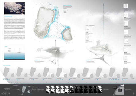
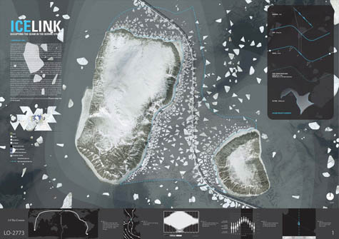 [Image: From "IceLink: Occupying the Temporal Seam" by Lateral Architecture].
In their submission to the recent competition to design a bridge across the Bering Strait – the Bering Strait Connection – Toronto's Lateral Architecture proposed "IceLink: Occupying the Temporal Seam."
Lateral Architecture, of course, are also the brains behind the excellent blog InfraNet Lab, as well as the designers of both the Air Unit and the awesome Runways to Greenways plan proposed for Iceland – and IceLink is no less interesting than either of those.
 [Image: From IceLink by Lateral Architecture].
First, for those of you who did not see the original call for projects, the Bering Strait Connection described itself as a "project attempting to connect two continents":
- In a wide sense, it includes building a tunnel or a bridge at both ends of the strait, extending [the] existing railways of the United States and Russia, and laying a world highway around the coasts of the world, which requires a massive amount of construction.
Architects were asked to design "a peace park with a bridging structure using the two islands, Big Diomede and Little Diomede at the Bering Strait," and a "proposal of how to connect two continents."
 [Image: From IceLink by Lateral Architecture].
In response to this, then, Lateral proposed: "1) a tunnel/bridge hybrid that runs along the international date line and accumulates diplomatic programs, and 2) a seasonal ice park that harvests ice floes into a global water vault."
A global water vault: it's ideas like this that make me love architecture.
 [Image: From IceLink by Lateral Architecture].
So the site, of course, would straddle two very different timezones: that is, both today and tomorrow (or today and yesterday). If I wasn't living in a temporary apartment right now, and thus without access to my books, I would quote from Umberto Eco's intellectually pessimistic novel The Island of the Day Before. There, we read how a shipwrecked scientist repeatedly fails to come to grips with the temporal (and epistemological) fact of his maritime abandonment along the international date line.
But, perhaps to the benefit of my readers, I can't.
Instead, let me also mention The Cryptographer, a novel by Tobias Hill. While it would be hard actually to recommend the book, it's nonetheless worth mentioning Hill's use of the international date line as an origin point for a currency-destroying computer virus: the Date Line Virus. Hill's Date Line Virus spreads westward with the ticking of the clock – or the turning of the earth – erasing digital savings and scrambling all systems of measured economic value.
That is, the world's entirely computer-based monetary system, hour by hour, goes mad.
Clearly, then, from even only these two examples, the narrative possibilities – and intellectual stakes – of the international date line are fairly interesting to draw on. Or, for instance, check out this factoid, from that well-known source of scientific accuracy, Wikipedia:
- For two hours every day, at UTC 10:00–11:59, there are actually three different days observed at the same time. At UTC time Thursday 10:15, for example, it is Wednesday 23:15 in Samoa, which is eleven hours behind UTC, and it is Friday 00:15 in Kiritimati (separated from Samoa by the IDL), which is fourteen hours ahead of UTC. For the first hour (UTC 10:00–10:59), this phenomenon affects inhabited territories, whereas during the second hour (UTC 11:00–11:59) it only affects an uninhabited maritime time zone twelve hours behind UTC.
For two hours, in other words, there are three different days happening on the earth simultaneously.
But what about the spatial possibilities of the international date line?
How can this strange temporal fissure in the planet's political and cultural landscape be taken advantage of architecturally?
 [Image: From IceLink by Lateral Architecture].
IceLink, its designers write, without much surprise, "seeks to capitalize and highlight [the Strait's] unique geography, climate, and context." However, they add, "The intent here is less to impose a new landscape in this context than to emphasize the sublime conditions already existing. Currently, the Bering Strait is a seasonal barometer of the impacts of climate change. The intent with this scheme is to offer spaces with which to reflect on the correlation between natural environments and their occupation."
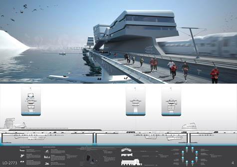
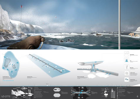
This is where we come to the project's "two primary infrastructural elements: a tunnel-bridge link and an ice park."
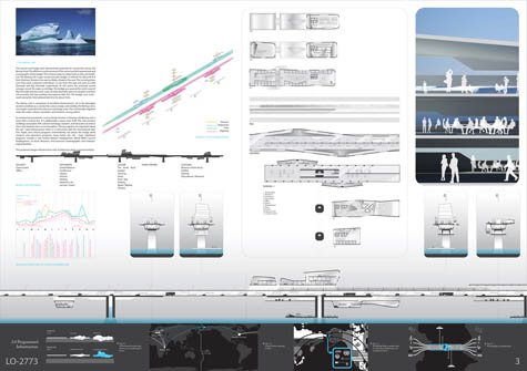 [Image: From IceLink by Lateral Architecture].
The so-called "Bering Link" half of the project would consist of "bundled infrastructures," the architects explain; these infrastructures would span a distance of 85km, from Dezhnev, Russia, to Wales, Alaska. In the process, the Bering Link would skirt the Diomede islands, and even travel north-south atop the date line for 4km.
Alongside this would be a series of new buildings, "concurrent with the international date line."
- Public and cultural programs intermittently rise above the bridge while research and education programs hang below the rail/road. Significant programs include a new United Nations headquarters, World Water Council headquarters, an Arctic Museum, and extensive oceanographic and meteorological facilities.
It's a little hard to believe that the United Nations would move its headquarters to the middle of the Bering Strait – after all, thriller-reading Christians know that they'll soon be moving it to Baghdad – but it's a pretty ingenious move to put the World Water Council headquarters out there.
Why?
Here we come to the second half of Lateral's project: the "Bering Ice Park," a kind of floating archive and index of global climate change:
- Sea ice is often trapped between the Diomedes prior to drifting northward. The new park seeks to enhance and highlight this phenomenon. The Bering Ice Park will cultivate, collect and distribute ice floes. The extent of the park is defined by the Diomedes coastlines facing the international border and date line as well as natural ocean currents movement north.
I'm reminded of BLDGBLOG's earlier look this month at the terroir of drinking water, in a guest post by Nicola Twilley: might specially cultivated Date Line Water™ from Lateral's Bering Ice Park someday arrive on the tables of high-end restaurants the world over?
As it happens: no. The project described here did not manage to find a place amongst the finalists of the design competition.
To see what did make the cut, take a look at the results over at Bustler.
(Lateral Architecture's Air Unit makes a brief appearance in The BLDGBLOG Book – so if you haven't yet picked up a copy, be sure to do so soon!)
-----
Via BLDBLOG
Related Links:
Personal comment:
Une architecture construite dans le détroit de Béring, sur la ligne de séparation temporelle et qui vit donc à la fois aujourd'hui et hier... intéressant.
fabric | rblg
This blog is the survey website of fabric | ch - studio for architecture, interaction and research.
We curate and reblog articles, researches, writings, exhibitions and projects that we notice and find interesting during our everyday practice and readings.
Most articles concern the intertwined fields of architecture, territory, art, interaction design, thinking and science. From time to time, we also publish documentation about our own work and research, immersed among these related resources and inspirations.
This website is used by fabric | ch as archive, references and resources. It is shared with all those interested in the same topics as we are, in the hope that they will also find valuable references and content in it.
