Thursday, April 30. 2009
Transports, logement, tours... Le chef de l'Etat a dessiné ce mercredi sa vision du Grand Paris, dont le chantier devra démarrer «avant 2012».

«Il faut voir grand. Il n'y a pas de fatalité de la métropole invivable.(...) Une ville n'est grande que si elle est grande aux yeux de tous ses hommes.» C'est un Nicolas Sarkozy aux accents lyriques qui a présenté ce mercredi après-midi sa vision du Grand Paris, à la Cité de l'Architecture à Paris.
Durant une quarantaine de minutes, le chef de l'Etat a détaillé les grands axes de ce projet qui a pour lui «une importance capitale»: architecture, transport, logement... Le tout étant placé sous la houlette de Christian Blanc, secrétaire d’Etat à la Région Capitale. Et le Président veut faire vite: le chantier devra démarrer «avant 2012», avec comme objectif de «faire le Grand Paris en dix ans».
Premier grand principe de cette agglomération remodelée: le développement de la vallée de la Seine, jusqu'au Havre, qui doit devenir «le port du grand Paris», «à une heure de la capitale». Le canal Seine-Nord «permettra de désenclaver la Seine dès 2010», a promis le chef de l'Etat, qui veut «reconquérir les berges de la Seine, de la Marne, du canal de l'Ourcq.»
Après quelques considérations sur Victor Hugo, «le vrai, le beau, le grand» et le relativisme de la beauté — «La beauté, on l'a trop oubliée. Sans doute le beau est-il subjectif... Mais ce n'est pas une raison pour éluder la question!» — Nicolas sarkozy s'est dit favorable à la construction de tours: «On peut construire haut, pourquoi s'interdire des tours si elle sont belles?» De même qu'à la réalisation à Roissy d'une forêt «d'un million d'arbres».
«70.000 nouveaux logements par an»
Le chef de l'Etat a également tranché sur la question du nouvel emplacement de la Cité judiciaire: «Elle doit s'installer aux Batignolles.» Avant les Batignolles (XVIIe arrondissement), le projet d'un déménagement du palais de justice, actuellement dans l'île de la Cité (Ier), avait tourné autour du XIIIe arrondissement et du nouveau quartier Paris Rive Gauche.
Mais les principales annonces du discours présidentiel concernent le logement et le transport.
S'agissant du logement, Sarkozy promet «la construction de 70.000 logements par an, soit le double du rythme actuel». Comment ? «Le problème n'est pas le foncier, c'est la réglementation, a-t-til martelé. Il faut déréglementer. Libérer l'ordre de l'urbanisme, élever le coefficient d'occupation des sols, rendre constructibles les zones inondables par des bâtiments adaptés, utiliser les interstices.»
Les transports, dans le Grand Paris tel que le conçoit le Président, seront d'autre part considérablement renforcé. «Se déplacer pour aller travailler est devenu un enfer pour des millions de gens. Ça ne peut plus durer.»
Le chef de l'Etat souhaite d'abord «optimiser le réseau existant»: faire fonctionner les transports la nuit, avoir une seule régulation du trafic pour le réseau RATP et celui de la SNCF. Et pourquoi pas une tarification unique: «On pourra pas faire l'économie de cette réflexion».
35 milliards d'euros
Mais il faut aussi, selon lui, compléter le réseau: prolonger la ligne 14, créer une liaison rapide Roissy-gare du Nord... Et, c'est l'un des grands points du volet transport, créer un un «nouveau système» pour relier, en boucle, les grands points de polarité, sur 130 km. Ce supermétro sera «si possible aérien, rêvons qu'il soit une vitrine mondiale de notre savoir-faire en matière de transport». Ce «grand huit» (21 milliards d'euros) reliera des pôles d'activité (Roissy, Orly, La Défense, Saclay, Massy, Clichy-Montfermeil, Noisy, grand hub multimodal à Saint-Denis/Pleyel...) et les principaux centres d'habitat.
Le financement de l'opération, que le chef de l'Etat chiffre à 35 milliards en tout, reposera sur «des investissements» mais aussi sur «la valorisation du foncier», «l'augmentation de la fréquentation des transports en commun» et les partenariats public-privé.
Un projet de loi sera déposé en octobre qui fixera les «modalités de maîtrise d'ouvrage des structures juridiques, et de modalités de financement».
-----
Via Libération
Personal comment:
Quelques idées intéressantes mais on est dans le réalisme et les idées "usual suspects" actuelles: densification, transports publics, connectivité aux réseaux (pensés plutôt réseaux physiques de transports), éco-quartiers ou éco-tours, quartiers-tours, etc.
Pas vraiment d'utopies ou de grandes idées même si le Grand Paris est probablement déjà en soi une grande idée...
Tuesday, April 28. 2009
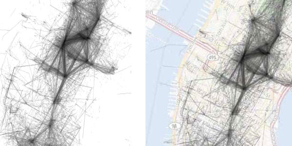
The recently presented academic paper at the WWW 2009 Conference from a group of computer science academics from Cornell University investigates the collection of roughly 35 million geotagged photos collected from Flickr, uploaded by more than 300,000 users. Their approach used in Mapping the World's Photos [www2009.eprints.org, PDF] combines content analysis based on text tags and image data with structural analysis based on geospatial data. While individual users of Flickr are simply using the site to store and share photos, their collective activity reveals a striking amount of geographic and visual information about the world.
For instance, their findings show that the Fifth Avenue Apple Store, which opened in May 2006, is more popular than many other well-known tourist sites such as St Paul's Cathedral in London, the Reichstag in Berlin and the Washington Monument in the US capital.
Interesting visualizations include diagrams for Manhattan and the San Francisco Bay area that illustrate the movement of photographers by plotting the geolocated coordinates of sequences of images taken by the same user, sorted by time, for which consecutive photos were no more than 30 minutes apart. "The figures are striking in the amount of detail they reveal about these cities. For example, one can clearly see the grid structure of the Manhattan streets, caused by users traveling and taking photos along them. The Brooklyn Bridge, in the lower center of the figure, is clearly visible, as are the Manhattan and Williamsburg bridges just to the north. One can even see the route of the ferries that take tourists from Lower Manhattan to the Statue of Liberty".
Another figure shows maps of representative images for the top landmarks in each of the top 20 North American and European cities. It raises the intriguing possibility of an online travel guidebook that could automatically identify the best sites to visit on one's next vacation, as judged by the collective wisdom of the world's photographers.
See also World's Eyes. Via Sydney Morning Herald.
-----
Via Information aesthetics
Personal comment:
Intéressant évidemment de constater que l'on tire de plus en plus d'informations à partir de site regroupant des données (ici Flickr, des photos "taguées"). Les traces qu'on laisse ici et là sont analysables, etc. On connait désormais la litanie.
Toutefois, quand par exemple ici les auteurs croient un peu aveuglément dans leur analyses (par exemple que l'Apple Store de la cinquième avenue est plus populaire que le Reichstag ou la cathédrale St Paul), je me dis qu'ils devraient pondérer leurs résultats par d'autres facteurs, socio-ethonologique. Par exemple que les personnes qui vont visiter un Apple Store (ce qui en soit est assez inquiétant) sont peut-être plus nerdy, équipés en enclin à prendre celui-ci en photo et le poster sur Flickr que des personnes qui visitent la cathédrale St-Paul.
Tout ça pour questionner un peu ces "trouvailles" ...
Monday, April 27. 2009
Mimi Ito, Daisuke Okabe, and Ken Anderson have an interesting chapter in the edited volume by Rich Ling & Scott Campbell (2009) “The reconstruction of space and time: mobile communication practices” which recently came out. The chapter is called “Portable Objects in Three Global Cities: The Personalization of Urban Places”. The authors explore how people use portable objects to ‘interface’ with urban space and locations. Up to now, the authors say, the dominant focus has been on conceptualizing the mobile phone as a personal communications technology. The emphasis in such studies has been on how interpersonal communication has been made possible “anytime, anyplace, anywhere”. To a much lesser extend the mobile phone has been conceptualized as a device that is tied to local situations. In this approach the mobile phone is seen as an interface to urban space. Mobile communication infrastructure intersects with the physical infrastructure of the city [1].
Ito et al do not look at the mobile phone on its own. Instead, they take the phone as but one of the portable objects that are ‘interfaces’ to the city. These include media players, books, keys, credit and transit cards, identity and member cards. Together these comprise “the information-based ‘mobile kits’ of contemporary urbanites” (p. 67). So the mobile phone, instead of being studied in isolation, is part of a larger assembly of objects that people use to navigate the city, as well as to sustain social relations with other people [2]. Next they discuss three kinds of urban interfacing, which they have labelled cocooning, camping, and footprinting. Cocooning is the practise of people shielding themselves off in public settings. For instance by using portable media players, books, doing stuff on their mobile phones, etc. They create an invisible bubble of mobile private space around them. Camping is the practise of finding a nice spot in town - often in coffeehouses - and doing information related work there with laptops, mobile phones, etc. This can be both for work and private affairs (and often intermingle). Camping can co-exist with cocooning when people shield themselves off from physical social interactions through portable media objects. Footprinting describes the various customer transaction and loyalty schemes through which people leave traces in a particular location. It is “the process of integrating an individual’s trajectory into the transactional history of a particular establishment, and customer cards are the mediating devices” (p. 79). The authors have done fieldwork research in three big cities: Tokyo, Los Angeles, and London. Interestingly, they conclude that behaviors vary only slightly between these cities.
I find this approach very interesting for a number of reasons. First, the conceptualization as ‘urban interfaces’ focusses on the locative qualities of mobile media. The paper gives a nice categorization of the various ways in which mobile media act as interfaces between ‘the digital’ and ‘the physical’. Second, the mobile phone is not studied in isolation but as part of a larger array of informational objects that people carry along with them to manage and deal with urban life. Consequently, the image of the mobile phone shifts from an intrusive addition to an imagined once upon a time of ‘real’ public space, face to face interactions, spontaneous encounters and serendipitous discovery, etc., to a more pragmatic view on the mobile as an everyday necessity of urbanites. Third, Ito et al connect changes in the urban experience to changes in displaying identity in public spaces. This point receives scant attention in the chapter but is very important indeed.
I also have some points of critique on this conceptualization and approach. First, Ito et al predominantly focus on the interaction of people with the physical localities and infrastructure of the city (p 71-72). They take infrastructure as a collection of ‘dead’ objects (roads, public transport entry ports, toll roads, etc.) making urban life possible. Location in their view refers solely to a point in Euclidian space, a coordinate on the map so to say. The authors leave out the human aspect of location and infrastructure. In their own words “it becomes even more crucial that mobile communications research look at these more infrastructural and impersonal forms of social and cultural practise” (p. 72 - my emphasis). Yet locations and infrastructures are only abstracted ‘ideal’ or ‘categorical’ concepts of their phenomenological equivalents in lived space. They are the abstract counterparts of places and routes (or trajectories). I would say we should look at the human side of infrastructures as crossroads of experiences, in the vein of what geographer Doreen Massey has called the “throwntogetherness” of place as an event [3]. Of course many locative media projects exactly tried to visualize this human aspect of infrastructures and locations (e.g. Christian Nold’s biomapping).
A second critique on this approach is that it considers only one side of the hybrid relation between physical space and digitally mediated space. This conceptual framework gives prevalence to physical space over digital space. The main focus is on how the digital ’seeps’ into the physical and alters pre-existing situations there. But how does the physical seep into the digital realm? It is one-way, departing from the assumption of what Lev Manovich has called “augmented space” as an overlay of physical space [4]. This suggests that digital space is an extra layer to reality. As De Souza e Silva has argued, this idea of augmented space gives prevalence to behavior in the physical realm, rather than the interactions that take place in both types of spaces at the same time [5]. Instead, she argues, we must look at digitally mediated social behavior as taking place in ‘hybrid space’ [5].
Thirdly, important other location-based uses of portable information objects are being left out, such as navigation and wayfinding in (unknown) cities. The focus seems restricted to urban practises by people who actually inhabit or at least regularly frequent the city. In addition, footprinting is depicted as taking place solely in the commercial realm through customer loyalty cards. There is an abundance of locative media project that use geotagging as a way of leaving digital footprints or graffiti in the city (e.g. Dutch project Bliin). And the mobile device itself increasingly becomes the interface to footprinting. Many new high-end devices have automatic geotagging built in their photo camera, and come with various uploading services. Some devices already have NFC technology for micro-payments. It seems logical that more and more portable informational objects will converge into the mobile device. Will it ever come to the point that The Mobile City becomes “the city in our mobile”?
[1] It should be noted that in most writings on ‘locative’ aspects of mobile media there is an almost exclusive focus on the city as the locus of action. This is understandable since in the city many of the networks that make up present-day ‘hybrid space’ are present in much greater density, and arguably with much greater consequences. In what ways rural space is changing under the influence of mobile media is understudied, I guess, and probably just as important. Especially if we consider that according to Claude Fisher (1992) who studied early fixed line telephony certainly in the beginning the telephone has been more important for rural living than for urban living.
[2] A similar point about the research bias towards studying single technologies is made by Julsrud & Bakke in chapter 7 of this same volume (p. 160).
[3] Massey, D. B. (2005). For space. London; Thousand Oaks: SAGE. p. 140.
[4] Manovich, L. (2005). The Poetics of Augmented Space: Learning from Prada. 1-15. Retrieved from http://www.manovich.net/TEXTS_07.HTM
[5] De Souza e Silva, A. (2006). From Cyber to Hybrid: Mobile Technologies as Interfaces of Hybrid Spaces. Space and culture, 9(3), 261-278. Retrieved from http://www.lib.ncsu.edu/resolver/1840.2/80
-----
Via The Mobile City
Personal comment:
Un livre à la thématique pas vraiment surprenante, mais qui va dans le sens des concepts que nous utilisons tels que "relations spatiales médiatisées", "spatialités médiatisées", etc.
One of the oldest terms to think about the influence of both transport and communication technologies on the experience of time and space is “time-space compression”. This notion expresses the sense that the experience of time passing by is accelerated while the importance of distance diminished. Geographer David Harvey made the term famous, although it has been in use much longer. Sociologist John Urry quotes an anonymous English commentator who in 1839 says that the new railway system were “having the effect of ‘compressing’ time and space” and that “distances were thus annihilated” (Urry 2007: 96). This latter expression is made famous by Karl Marx who talked about “the annihilation of space by time”. At the same time commenters (e.g. Nigel Thrift) have noted that the immensive speed-up of transport and communication technologies not only lead to shrinkage but also to enlargement and widening of space and time, since people could now get a sense of other worlds beyond their previously known local one and simultaneous presence with people elsewhere.
Recently I stumbled across two examples that explore its very edges. The first is a fascinating map of the remotest place on earth.
The maps are based on a model which calculated how long it would take to travel to the nearest city of 50,000 or more people by land or water. The model combines information on terrain and access to road, rail and river networks. It also considers how factors such as altitude, steepness of terrain and hold-ups like border crossings slow travel. Plotted onto a map, the results throw up surprises. First, less than 10 per cent of the world’s land is more than 48 hours of ground-based travel from the nearest city. What’s more, many areas considered remote and inaccessible are not as far from civilisation as you might think. In the Amazon, for example, extensive river networks and an increasing number of roads mean that only 20 per cent of the land is more than two days from a city - around the same proportion as Canada’s Quebec province.
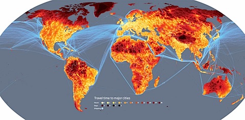
(image source)
The map is created by researchers at the European Commission’s Joint Research Centre in Ispra, Italy, and the World Bank. It is part of a research that measures urbanisation from the new perspective of travel time to 8500 major cities. Key findings are:
- we passed the point at which more than half the world’s populations live in cities around the turn of the Millennium (2000) - much earlier than the 2007/8 estimate;
- more than half of the world’s population lives less than 1 hour from a major city, but the breakdown is 85% of the developed world and only 35% of the developing world;
- 95% of the world’s population is concentrated on just 10% of the world’s land; but
- only 10% of the world’s land area is classified as “remote” or more than 48 hours from a large city.
The map beautifully shows just how incredibly connected the world has become - not only via telecommunications but also by physical mobility - and how even the remotest regions are now closely tied to the urban sphere. The fact that 10% of the world is more than 48 hours from a large city raises questions about the definition of ‘urban’, as states the news release. More nice maps here.
A second example is the Reuters news that a Nepali telecom firm is planning to expand its mobile phone service to the top of the Mount Everest. The Mount Everest is one of the busiest high mountains. Each year hundreds of climbers attempt to reach the summit. Until now they were dependent on expensive satellite telephones to call family and friends from the top. Now even the highest peak on earth will become connected to the worldwide communication networks.
The question of course remains whether this potential for mobility and connection to ‘the global’ actually contributes to a worldwide “imagined community”. What this map does not indicate is that mobility and connections are unequally divided. Doreen Massey has called this “the power-geometry of time-space compression” (see article). While for global and digital ‘neo-nomads’ the world may indeed seem one homogeneous ’smooth space’, for others it remains firmly divided by barriers and obstacles.
-----
Via The Mobile City
Wednesday, April 22. 2009

Dan Kildee, the county treasurer of Flint, Mich., in front of the home where he lived until he was 4. He is proposing the tearing down of entire blocks and even whole neighborhoods.
FLINT, Mich. — Dozens of proposals have been floated over the years to slow this city’s endless decline. Now another idea is gaining support: speed it up. Instead of waiting for houses to become abandoned and then pulling them down, local leaders are talking about demolishing entire blocks and even whole neighborhoods. The population would be condensed into a few viable areas. So would stores and services. A city built to manufacture cars would be returned in large measure to the forest primeval. “Decline in Flint is like gravity, a fact of life,” said Dan Kildee, the Genesee County treasurer and chief spokesman for the movement to shrink Flint. “We need to control it instead of letting it control us.”
The recession in Flint, as in many old-line manufacturing cities, is quickly making a bad situation worse. Firefighters and police officers are being laid off as the city struggles with a $15 million budget deficit. Many public schools are likely to be closed. “A lot of people remember the past, when we were a successful city that others looked to as a model, and they hope. But you can’t base government policy on hope,” said Jim Ananich, president of the Flint City Council. “We have to do something drastic.” In searching for a way out, Flint is becoming a model for a different era. Planned shrinkage became a workable concept in Michigan a few years ago, when the state changed its laws regarding properties foreclosed for delinquent taxes. Before, these buildings and land tended to become mired in legal limbo, contributing to blight. Now they quickly become the domain of county land banks, giving communities a powerful tool for change.
Indianapolis and Little Rock, Ark., have recently set up land banks, and other cities are in the process of doing so. “Shrinkage is moving from an idea to a fact,” said Karina Pallagst, director of the Shrinking Cities in a Global Perspective Program at the University of California, Berkeley. “There’s finally the insight that some cities just don’t have a choice.” While the shrinkage debate has been simmering in Flint for several years, it suddenly gained prominence last month with a blunt comment by the acting mayor, Michael K. Brown, who talked at a Rotary Club lunch about “shutting down quadrants of the city.” Nothing will happen immediately, but Flint has begun updating its master plan, a complicated task last done in 1965. Then it was a prosperous city of 200,000 looking to grow to 350,000. It now has 110,000 people, about a third of whom live in poverty.
Flint has about 75 neighborhoods spread out over 34 square miles. It will be a delicate process to decide which to favor, Mr. Kildee acknowledged from the driver’s seat of his Grand Cherokee. He will play a crucial role in those decisions. In addition to being the treasurer of Genesee County, whose largest city by far is Flint, Mr. Kildee is chief executive of the local land bank. In the last year, the county has acquired through tax foreclosure about 900 houses in the city, some of them in healthy neighborhoods. A block adjacent to downtown has the potential for renewal; it would make sense to fill in the vacant lots there, since it is a few steps from a University of Michigan campus.
A short distance away, the scene is more problematic. Only a few houses remain on the street; the sidewalk is so tattered it barely exists. “When was the last time someone walked on that?” Mr. Kildee said. “Most rural communities don’t have sidewalks.” But what about the people who do live here and might want their sidewalk fixed rather than removed? “Not everyone’s going to win,” he said. “But now, everyone’s losing.” On many streets, the weekly garbage pickup finds only one bag of trash. If those stops could be eliminated, Mr. Kildee said, the city could save $100,000 a year — one of many savings that shrinkage could bring.
Mr. Kildee was born in Flint in 1958. The house he lived in as a child has just been foreclosed on by the county, so he stopped to look. It is a little blue house with white trim, sad and derelict. So are two houses across the street. “If it’s going to look abandoned, let it be clean and green,” he said. “Create the new Flint forest — something people will choose to live near, rather than something that symbolizes failure.” Watching suspiciously from next door is Charlotte Kelly. Her house breaks the pattern: it is immaculate, all polished wood and fresh paint. When Ms. Kelly, a city worker, moved to the street in 2002, all the houses were occupied and the neighborhood seemed viable.
These days, crime is brazen: two men recently stripped the siding off Mr. Kildee’s old house, “laughing like they were going to a picnic,” Ms. Kelly said. Down the street are many more abandoned houses, as well as a huge hand-painted sign that proclaims, “No prostitution zone.” “It saddens my heart,” she said. “I was born in Flint in 1955. I’ve seen it in the glory days, and every year it gets worse.” Mr. Kildee makes his pitch. Would she be interested in moving if the city offered her an equivalent or better house in a more stable and safer neighborhood? Despite her pride in her home, the calculation takes Ms. Kelly about a second. “Yes,” she said, “I would be willing.”
-----
Via The New York Times
Personal comment:
Le moment ou certaines villes (ex-industrielles) doivent planifier leur "rétrécissement". Ici Flint, Michigan (rappelez-vous le documentaire de Michael Moore --Roger & Me-- sur sa ville natale, fief de l'industrie automobile et de l'Amérique prospère dans les années 1950).
Intéressant d'un point de vue urbain mais aussi d'un point de vue conceptuel/durabilité. Will less be more (one more time)?
|
